Geolocate

Villaretto topographic map

Click on the map to display elevation.

About this map

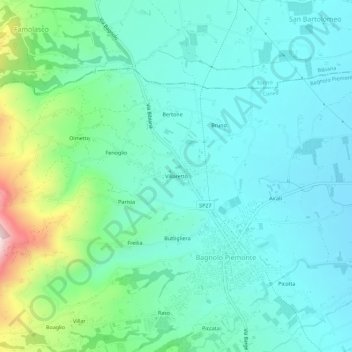
Name: Villaretto topographic map, elevation, terrain.

Location: Villaretto, Bagnolo Piemonte, Cuneo, Piemonte, 12031, Italia (44.74953 7.28600 44.78953 7.32600)

Average elevation: 408 m

Minimum elevation: 325 m

Maximum elevation: 711 m

Gear up for your next adventure:

🥾Light Trekking Boots - Supportive boots for multi-day treks
🛰️Satellite Messenger - Emergency communication for areas with no cell service
Camping Groundsheet - Protect your tent from moisture and dirt
🦶Hiking Shoe Insoles - Added support for high arches and long days on feet
🧥Thermal Layer - Insulating layer for cold outdoor conditions

As an Amazon Associate, this site earns from qualifying purchases at no extra cost to you.