
South Ayrshire topographic map
Interactive map
Click on the map to display elevation.
About this map
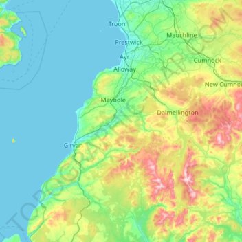
Name: South Ayrshire topographic map, elevation, terrain.
Location: South Ayrshire, Scotland, United Kingdom (54.99764 -5.06097 55.60187 -4.39886)
Average elevation: 151 m
Minimum elevation: 0 m
Maximum elevation: 834 m
The number of hours of natural sunshine in South Ayrshire is controlled by the length of day and by cloudiness. In general, December is the dullest month and May or June the sunniest. Sunshine duration decreases with increasing altitude, increasing latitude and distance from the coast. Local topography also exerts a strong influence and in the winter deep glens and north-facing slopes can be in shade for long periods. Industrial pollution and smoke haze can also reduce sunshine amounts, but the decline in heavy industry in the Ayrshire area, primarily in Ayr in South Ayrshire along with Kilmarnock in East Ayrshire, has resulted in an increase in sunshine duration particularly in the winter months.
Other topographic maps
Click on a map to view its topography, its elevation and its terrain.
Garmouth
United Kingdom > Scotland > Moray
Garmouth, Moray, Scotland, IV32 7PD, United Kingdom
Average elevation: 11 m
Alford
United Kingdom > Scotland > Aberdeenshire
Alford, Aberdeenshire, Scotland, AB33 8PX, United Kingdom
Average elevation: 189 m
Larkhall
United Kingdom > Scotland > South Lanarkshire
Larkhall, South Lanarkshire, Scotland, ML9 1DR, United Kingdom
Average elevation: 114 m
Viewfield
United Kingdom > Scotland > Scottish Borders
Viewfield, Scottish Borders, Scotland, TD10 6UW, United Kingdom
Average elevation: 136 m
Arthur's Seat
United Kingdom > Scotland > City of Edinburgh
Arthur's Seat, City of Edinburgh, Scotland, EH8 8HG, United Kingdom
Average elevation: 69 m
Dyke
United Kingdom > Scotland > Moray
Dyke, Moray, Scotland, IV36 2TJ, United Kingdom
Average elevation: 24 m
Airdrie
United Kingdom > Scotland > North Lanarkshire
Airdrie, North Lanarkshire, Scotland, ML6 6BU, United Kingdom
Average elevation: 136 m
Hawick
United Kingdom > Scotland > Scottish Borders
Hawick, Scottish Borders, Scotland, TD9 9EG, United Kingdom
Average elevation: 199 m
Langholm
United Kingdom > Scotland > Dumfries and Galloway
Langholm, Dumfries and Galloway, Scotland, DG13 0JQ, United Kingdom
Average elevation: 185 m
North Berwick
United Kingdom > Scotland > East Lothian
North Berwick, East Lothian, Scotland, EH39 4HE, United Kingdom
Average elevation: 21 m
St Andrews
United Kingdom > Scotland > Fife
St Andrews, Fife, Scotland, KY16 9PA, United Kingdom
Average elevation: 38 m
Pierowall
United Kingdom > Scotland > Orkney Islands
Pierowall, Orkney Islands, Scotland, KW17 2DJ, United Kingdom
Average elevation: 20 m
Ruthven
United Kingdom > Scotland > Aberdeenshire
Ruthven, Aberdeenshire, Scotland, AB54 4SG, United Kingdom
Average elevation: 132 m
Carnell (Carnhill)
United Kingdom > Scotland > South Ayrshire
Carnell (Carnhill), South Ayrshire, Scotland, KA1 5JS, United Kingdom
Average elevation: 96 m
Findhorn
United Kingdom > Scotland > Moray
Findhorn, Moray, Scotland, IV36 3YG, United Kingdom
Average elevation: 3 m
Kirkcaldy
United Kingdom > Scotland > Fife
Kirkcaldy, Fife, Scotland, KY1 1JA, United Kingdom
Average elevation: 50 m
Stromness
United Kingdom > Scotland > Orkney Islands
Stromness, Orkney Islands, Scotland, KW16 3BU, United Kingdom
Average elevation: 21 m
Culloden
United Kingdom > Scotland > Highland
Culloden, Highland, Scotland, United Kingdom
Average elevation: 51 m
Forres
United Kingdom > Scotland > Moray
Forres, Moray, Scotland, IV36 1NX, United Kingdom
Average elevation: 31 m
Bellshill
United Kingdom > Scotland > North Lanarkshire
Bellshill, North Lanarkshire, Scotland, ML4 1AJ, United Kingdom
Average elevation: 73 m
Willie's Law
United Kingdom > Scotland > Scottish Borders
Willie's Law, Scottish Borders, Scotland, United Kingdom
Average elevation: 472 m
Ben Macdui
United Kingdom > Scotland > Aberdeenshire
Ben Macdui, Aberdeenshire, Scotland, United Kingdom
Average elevation: 1,031 m
Bothwell
United Kingdom > Scotland > South Lanarkshire
Bothwell, South Lanarkshire, Scotland, G71 8RB, United Kingdom
Average elevation: 65 m
Braemar
United Kingdom > Scotland > Aberdeenshire
Braemar, Aberdeenshire, Scotland, AB35 5YN, United Kingdom
Average elevation: 445 m
Newton Mearns
United Kingdom > Scotland > East Renfrewshire
Newton Mearns, East Renfrewshire, Scotland, G77 6EY, United Kingdom
Average elevation: 127 m
Cairnhill
United Kingdom > Scotland > North Lanarkshire > Airdrie
Cairnhill, Airdrie, North Lanarkshire, Scotland, ML6 9RW, United Kingdom
Average elevation: 112 m
Iona
United Kingdom > Scotland > Argyll and Bute > The Village
Iona, The Village, Argyll and Bute, Scotland, United Kingdom
Average elevation: 9 m
Kirkwall
United Kingdom > Scotland > Orkney Islands
Kirkwall, Orkney Islands, Scotland, KW15 1DH, United Kingdom
Average elevation: 27 m
Dunphail
United Kingdom > Scotland > Moray
Dunphail, Moray, Scotland, IV36 2QQ, United Kingdom
Average elevation: 192 m
Bowling
United Kingdom > Scotland > West Dunbartonshire
Bowling, West Dunbartonshire, Scotland, G60 5AH, United Kingdom
Average elevation: 105 m
Morar
United Kingdom > Scotland > Highland
Morar, Highland, Scotland, PH40 4PH, United Kingdom
Average elevation: 30 m
Carron
United Kingdom > Scotland > Falkirk
Carron, Falkirk, Scotland, FK2 8DS, United Kingdom
Average elevation: 16 m
Sandbank
United Kingdom > Scotland > Argyll and Bute
Sandbank, Argyll and Bute, Scotland, PA23 8PJ, United Kingdom
Average elevation: 100 m
Wick
United Kingdom > Scotland > Highland
Wick, Highland, Scotland, KW1 4NB, United Kingdom
Average elevation: 20 m
Portgordon
United Kingdom > Scotland > Moray
Portgordon, Moray, Scotland, AB56 5TL, United Kingdom
Average elevation: 22 m
Burray
United Kingdom > Scotland > Orkney Islands
Burray, Orkney Islands, Scotland, United Kingdom, Burray
Average elevation: 7 m
Port Bannatyne
United Kingdom > Scotland > Argyll and Bute
Port Bannatyne, Argyll and Bute, Scotland, PA20 0LW, United Kingdom
Average elevation: 52 m
Cumbernauld
United Kingdom > Scotland > North Lanarkshire
Cumbernauld, North Lanarkshire, Scotland, United Kingdom
Average elevation: 113 m
Viewpark
United Kingdom > Scotland > North Lanarkshire
Viewpark, North Lanarkshire, Scotland, G71 6HL, United Kingdom
Average elevation: 62 m
Callander
United Kingdom > Scotland > Stirling
Callander, Stirling, Scotland, FK17 8DZ, United Kingdom
Average elevation: 203 m
Duns
United Kingdom > Scotland > Berwickshire
Duns, Berwickshire, Scotland, TD11 3DR, United Kingdom
Average elevation: 130 m
Cranston
United Kingdom > Scotland > Midlothian > Ford
Cranston, Ford, Midlothian, Scotland, EH37 5UB, United Kingdom
Average elevation: 154 m
Leapark
United Kingdom > Scotland > Angus > Royal Burgh of Forfar
Leapark, Royal Burgh of Forfar, Angus, Scotland, DD8 2RN, United Kingdom
Average elevation: 104 m
Millhill
United Kingdom > Scotland > North Ayrshire
Millhill, North Ayrshire, Scotland, KA27 8HQ, United Kingdom
Average elevation: 163 m
Tiree
United Kingdom > Scotland > Argyll and Bute > Balevullin
Tiree, Balevullin, Argyll and Bute, Scotland, United Kingdom
Average elevation: 3 m
Colonsay
United Kingdom > Scotland > Argyll and Bute > Scalasaig
Colonsay, Scalasaig, Argyll and Bute, Scotland, United Kingdom
Average elevation: 11 m
Cumnock
United Kingdom > Scotland > East Ayrshire
Cumnock, East Ayrshire, Scotland, KA18 1AY, United Kingdom
Average elevation: 187 m
Scarp
United Kingdom > Scotland > Western Isles
Scarp, Western Isles, Scotland, United Kingdom
Average elevation: 56 m
Galashiels
United Kingdom > Scotland > Scottish Borders
Galashiels, Scottish Borders, Scotland, United Kingdom
Average elevation: 221 m