Geolocate

Brunei topographic map

Interactive map

Click on the map to display elevation.

About this map

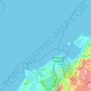
Name: Brunei topographic map, elevation, terrain.

Location: Brunei (4.00251 113.01793 6.54658 115.36356)

Average elevation: 100 m

Minimum elevation: -3 m

Maximum elevation: 2,223 m

Other topographic maps

Click on a map to view its topography, its elevation and its terrain.

Toronto

Canada > Ontario > Toronto

Despite its deep ravines, Toronto is not remarkably hilly, but its elevation does increase steadily away from the lake. Elevation differences range from 76.5 metres (251 ft) above sea level at the Lake Ontario shore to 209 m (686 ft) ASL near the York University grounds in the city's north end at the…

Average elevation: 113 m

Metchley

United Kingdom > England > Birmingham

Average elevation: 150 m

Lisbon

Portugal > Lisbon > Lisbon

Average elevation: 51 m

Banff

Canada > Alberta > Banff > Banff

Banff is a town within Banff National Park in Alberta, Canada. It is located in Alberta's Rockies along the Trans-Canada Highway, approximately 126 km (78 mi) west of Calgary and 58 km (36 mi) east of Lake Louise. At 1,400 to 1,630 m (4,590 to 5,350 ft) above sea level, Banff is the community with the second…

Average elevation: 1,615 m

Great Dividing Range

Australia

The Great Dividing Range, also known as the East Australian Cordillera or the Eastern Highlands, is a cordillera system in eastern Australia consisting of an expansive collection of mountain ranges, plateaus and rolling hills, that runs roughly parallel to the east coast of Australia and forms the…

Average elevation: 117 m

Lucknow

India > Uttar Pradesh > Lucknow

Lucknow stands at an elevation of approximately 123 metres (404 ft) above sea level. The city had an area of 402 km2 (155 square miles) until December 2019, when 88 villages were added to the municipal limits and the area increased to 631 km2 (244 square miles). Bounded on the east by Barabanki, on the west by…

Average elevation: 120 m

Calgary

Canada > Alberta > Calgary

Average elevation: 1,106 m

Niagara Escarpment

Canada > Ontario > Burlington

Average elevation: 216 m

Rocky Mountains

United States > Wyoming > Teton County

Agriculture and forestry are major industries. Agriculture includes dryland and irrigated farming and livestock grazing. Livestock are frequently moved between high-elevation summer pastures and low-elevation winter pastures, a practice known as transhumance.

Average elevation: 2,292 m

USA

United States > Texas > Tarrant County > Arlington

Average elevation: 170 m

Thrissur

India > Kerala > Thrissur

Thrissur is the headquarters of Thrissur district, in the centre of the Indian state of Kerala. The city is 75 km north-east of Kochi, 133 km south-west of Coimbatore, 124 km south-east of Kozhikode and 151 km north of Changanacherry. The city is located in a hillock called Thekkinkadu Maidan which is the…

Average elevation: 36 m

Mammoth Lakes

United States of America > California > Mammoth Lakes

Mammoth Lakes is a town in Mono County, California, the county's only incorporated community. It is located immediately to the east of Mammoth Mountain, at an elevation of 7,880 feet (2,400 m). As of the 2010 United States Census, the population was 8,234, reflecting a 16% increase from the 2000 Census.

Average elevation: 2,184 m

Kingston

Canada > Ontario > Kingston

Average elevation: 94 m

San Mateo

Venezuela > Aragua State > Municipio Bolívar

Average elevation: 826 m

Saskatoon

Canada > Saskatchewan > Saskatoon

Average elevation: 492 m

Maple Ridge

Canada > British Columbia > Maple Ridge

Average elevation: 193 m

Juneau

United States > Alaska > Juneau

Average elevation: 374 m

Catia La Mar

Venezuela > Vargas State

Average elevation: 465 m

Andes

Argentina > Mendoza > Distrito Las Cuevas

The Andes Mountains are the highest mountain range outside Asia. The highest mountain outside Asia, Argentina's Mount Aconcagua, rises to an elevation of about 6,961 m (22,838 ft) above sea level. The peak of Chimborazo in the Ecuadorian Andes is farther from the Earth's center than any other location on the…

Average elevation: 6,208 m

Hamilton

Canada > Ontario > Hamilton

Average elevation: 181 m

Lake Louise

Canada > Alberta > Improvement District No. 9

Lake Louise is a hamlet within Banff National Park in Alberta, Canada. Named after Princess Louise, Duchess of Argyll, it lies in Alberta's Rockies on the Bow River, 3 km (1.9 mi) northeast of the lake that shares its name. Initially settled in 1884 as an outpost for the Canadian Pacific Railway, Lake Louise…

Average elevation: 1,617 m

Windsor

Canada > Ontario > Windsor

Average elevation: 185 m

Agravaram

India > Tamil Nadu > Wallajah

Average elevation: 196 m

Teluk Bayur

Indonesia > West Kalimantan > Kubu Raya

Average elevation: 5 m

Ahobilam

India > Andhra Pradesh > Allagadda

The pilgrimage site is divided into two main sections: Lower Ahobilam, where the principal village and the main temple complex are located, and Upper Ahobilam, approximately eight kilometers east, situated in a steep gorge hosting the revered Nava Narasimha temples — nine unique manifestations of Lord…

Average elevation: 269 m

Sutton

Canada > Ontario > York Region

Average elevation: 229 m

Seaforth

Canada > Ontario > Huron County > Huron East

Average elevation: 312 m

Nose Hill Park

Canada > Alberta > Calgary

Names currently associated with topographical features in and near Nose Hill Park reflect the impact of the European newcomers and European trade goods on the Peigan. For example, Spy Hill, the westward extension of Nose Hill, derived its present name from the aboriginal practice of communicating with distant…

Average elevation: 1,174 m

London

Canada > Ontario > London > London

London has a humid continental climate (Köppen Dfb), though due to its downwind location relative to Lake Huron and elevation changes across the city, it is virtually on the Dfa/Dfb (hot summer) boundary favouring the former climate zone to the southwest of the confluence of the South and North Thames Rivers,…

Average elevation: 268 m

Istanbul

Turkey > Istanbul > Fatih

Istanbul, located in northwestern Turkey, is a city that is uniquely situated across two continents, Europe and Asia, divided by the Bosphorus Strait. The city’s topography is characterized by a complex blend of hills, valleys, and coastal plains, which create a varied and scenic landscape. The European side…

Average elevation: 57 m

Perth

Canada > Ontario

Average elevation: 313 m

Guelph

Canada > Ontario > Guelph

This region of Ontario has cold winters and warm, humid summers, falling into the Köppen climate classification Dfb zone, with moderately high rainfall and snowfall. It is generally a couple of degrees cooler than lower elevation regions on the Great Lakes shorelines, especially so in winter, the exception…

Average elevation: 344 m

Matterhorn

Switzerland > Wallis > Visp > Zermatt > Tufteren

Average elevation: 2,190 m

White Top

United States > West Virginia > Randolph County

White Top is a knob and spur of Cheat Mountain in southeastern Randolph County, West Virginia, USA. Sitting at an elevation of 4,085 feet (1,245 m), it is located just west of the Shavers Fork of Cheat River and Cheat Bridge. While White Top was originally crossed by the Staunton–Parkersburg Turnpike,…

Average elevation: 1,159 m

Mount Tom

United States > California > Inyo County

Average elevation: 3,535 m

Chintamani

India > Karnataka > Chintamani taluk

Chintamani lies in the southeast of the South Indian state of Karnataka. It is in the heart of the Mysore Plateau at an average elevation of 865 m (2,838 ft). The Taluk geographically lies between 78°12′36″N 13°16′38″E / 78.21000°N 13.27722°E / 78.21000; 13.27722 and 77°51′39″N…

Average elevation: 886 m

Candiac

Canada > Saskatchewan > Montmartre No. 126

Average elevation: 686 m

Caribbean

Haiti

Rainfall varies with elevation, size and water currents, such as the cool upwellings that keep the ABC islands arid. Warm, moist trade winds blow consistently from the east, creating both rain forest and semi arid climates across the region. The tropical rainforest climates include lowland areas near the…

Average elevation: 20 m

New Brunswick

Canada > New Brunswick

Average elevation: 165 m

Tepic

Mexico > Nayarit > Tepic

Located in the central part of the state, it stands at an altitude of 915 metres (3,002 ft) above sea level, on the banks of the Río Mololoa and the Río Tepic, approximately 225 kilometres (140 mi) north-west of Guadalajara, Jalisco. Nearby are the volcanoes of San Juan, Las Navajas, and Sangangüey. Tepic…

Average elevation: 921 m

Villa de Álvarez

Mexico > Colima > Villa de Álvarez

Average elevation: 709 m

Sivakasi

India > Tamil Nadu > Sivakasi

Sivakasi is located at 9°27′00″N 77°49′00″E / 9.45°N 77.8167°E / 9.45; 77.8167 and has an average elevation of 101 metres (331 feet). The city is located in Virudhunagar district of the South Indian state, Tamil Nadu, at a distance of 74 km (46 mi) from Madurai. Sivakasi is located to the…

Average elevation: 104 m

Roorkee

India > Uttarakhand > Roorkee

Roorkee is located at 29°52′N 77°53′E / 29.87°N 77.88°E / 29.87; 77.88. It has an average elevation of 268 metres (879 ft).

Average elevation: 270 m

Jatinangor

Indonesia > West Java > Sumedang

Average elevation: 774 m

Mount Forbes

Canada > Alberta > Improvement District No. 9

Average elevation: 2,835 m

Mactaquac

Canada > New Brunswick > Bright Parish

Average elevation: 75 m

Canmore

Canada > Alberta > Town of Canmore

Elevation Place opened in April 2013 as Canmore's new recreation facility. Construction of the facility began in 2012 to replace the Canmore Recreation Centre (the community's old facility). The facility offers an 8-lane 25m lap pool, a world class climbing wall developed by Walltopia, two cardio rooms, a…

Average elevation: 1,565 m

Cochrane

Canada > Alberta > Town of Cochrane > Cochrane

Cochrane is situated at the base of Big Hill in the Bow River Valley. It sits at an elevation of 1,186 m (3,891 ft). The town is intersected by Highway 1A and Highway 22. Cochrane has a reputation for its western culture, which can easily be felt when one wanders the streets (particularly Main Street). The…

Average elevation: 1,205 m

Mount Royal

Canada > Quebec > Urban agglomeration of Montreal > Montreal

The hill is part of the Monteregian Hills situated between the Laurentians and the Appalachian Mountains. It gave its Latin name, Mons Regius, to the Monteregian chain. The hill consists of three peaks: Colline de la Croix (or Mont Royal proper) at 233 m (764 ft), Colline d'Outremont (or Mount Murray, in the…

Average elevation: 111 m

Peterborough

Canada > Ontario > Peterborough

Peterborough's topography is largely defined by land formations created by the receding Wisconsian glaciers 10,000–15,000 years ago. The South End and Downtown portions of the City sit on what was the bottom of the glacial Lake Peterborough—part of a glacial spillway created when glacial meltwaters from…

Average elevation: 235 m

Cambridge

Canada > Ontario > Cambridge

Average elevation: 295 m

St. Albert

Canada > Alberta > St. Albert

Average elevation: 681 m

Red Deer

Canada > Alberta > Red Deer

Average elevation: 918 m

Lethbridge

Canada > Alberta > Lethbridge

Its high elevation of 929 m (3,047.9 ft) and close proximity to the Rocky Mountains provides Lethbridge with cooler summers than other locations in the Canadian Prairies. These factors protect the city from strong northwest and southwest winds and contribute to frequent chinook winds during the winter.…

Average elevation: 918 m

Quthbullapur

India > Telangana > Pudur mandal

Average elevation: 618 m

Lac des Graines

Canada > Quebec > Charlevoix-Est > Saint-Siméon

Average elevation: 154 m

Mount Elbert

United States > Colorado > Lake County

Mount Elbert is the highest summit of the Rocky Mountains of North America. With an elevation of 14,438 feet (4400.58 m), it is also the highest point in the U.S. state of Colorado and the second-highest summit in the contiguous United States after Mount Whitney, which is slightly taller. The ultra-prominent…

Average elevation: 3,959 m

Bremner

Canada > Alberta > Strathcona County

Average elevation: 688 m

Turmero

Venezuela > Aragua State > Municipio Mariño

Average elevation: 779 m

Belleville

Canada > Ontario > Belleville

Average elevation: 107 m

Nagda

India > Madhya Pradesh > Nagda Tahsil

Average elevation: 484 m

Gopirampura

India > Rajasthan > Chaksu Tehsil

Average elevation: 316 m

Nandi Hills

Kenya > Nandi County > Nandi Hills > Nandi Hills ward

Nandi Hills is located in a highland area of Lush Green Rolling Hills at the edge of the Great Rift Valley in the southwestern part of Kenya. It is located approximately 303 kilometres (188 mi), by road, northwest of Nairobi, the capital and largest city in the country. The coordinates of Nandi Hills, Kenya…

Average elevation: 2,028 m

Kirkjufell

Iceland > Grundarfjarðarbær

Average elevation: 34 m

Snowdon

United Kingdom > Wales > Gwynedd

Snowdon (/ˈsnoʊdən/), or Yr Wyddfa (Welsh: [ər ˈʊɨ̞̯ðva] ), is a mountain in Snowdonia in North Wales. It has an elevation of 1,085 metres (3,560 ft) above sea level, which makes it both the highest mountain in Wales and the highest in the British Isles south of the Scottish Highlands. Snowdon is…

Average elevation: 692 m

Dallas, TX

United States of America > Texas > Dallas, TX

Average elevation: 158 m

Machu Picchu

Peru > Cusco > Machupicchu

Average elevation: 2,227 m

Labasa

Fiji > Northern > Macuata

Average elevation: 30 m

Longyearbyen

Norway

Average elevation: 181 m

Tuxtla

Mexico > Puebla > Zapotitlán de Méndez

Average elevation: 912 m

Bruce Peninsula

Canada > Ontario > Grey County > Georgian Bluffs

Average elevation: 240 m

Okotoks

Canada > Alberta > Town of Okotoks

Average elevation: 1,096 m

Klintonel

Canada > Saskatchewan > White Valley No. 49

Average elevation: 1,094 m

Mehta Chowk

India > Punjab > Baba Bakala Tahsil

Average elevation: 245 m

Whistler Mountain

Canada > British Columbia > Squamish-Lillooet Regional District > Whistler

There is a weather station near the summit of Whistler Mountain at the Roundhouse Lodge, located at an elevation of 1835 m (6020 ft). Whistler Roundhouse has a dry-summer subalpine climate (Köppen Dsc), bordering on an Alpine climate (Köppen ET).

Average elevation: 1,810 m