
Philadelphia topographic map
Click on the map to display elevation.
About this map
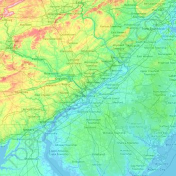
Name: Philadelphia topographic map, elevation, terrain.
Location: Philadelphia, Pennsylvania, 19140, United States (39.31145 -75.83265 40.71145 -74.43265)
Average elevation: 68 m
Minimum elevation: -4 m
Maximum elevation: 496 m
Other topographic maps
Click on a map to view its topography, its elevation and its terrain.
Bellevue
United States > Pennsylvania > Allegheny County
According to the United States Census Bureau, the borough has a total area of 1.1 square miles (2.8 km2), of which 1.0 square mile (2.6 km2) is land and 0.1 square miles (0.26 km2), or 9.09%, is water. Its average elevation is 997 feet (304 m) above sea level.
Average elevation: 285 m
Wind Gap
United States > Pennsylvania > Northampton County
Wind Gap is located 21 miles (34 km) north of Allentown in the Lehigh Valley and 50 miles (80 km) southeast of Scranton, in the Wyoming Valley, or the Scranton/Wilkes-Barre metropolitan area. Wind Gap's elevation is 755 feet (230 m) above sea level.
Average elevation: 255 m
Cresson
United States > Pennsylvania > Cambria County
Cresson is a borough in Cambria County, Pennsylvania, United States. Cresson is 80 miles (130 km) east of Pittsburgh. It is above 2,000 feet (600 m) in elevation. Lumber, coal, and coke yards were industries that had supported the population, which numbered 1,470 in 1910. The borough is part of the Johnstown…
Average elevation: 637 m
Pocono Pines
United States > Pennsylvania > Monroe County > Tobyhanna Township
Average elevation: 556 m
Bernville
United States > Pennsylvania > Berks County
Northkill Creek feeds into Blue Marsh Lake, and the Blue Marsh slackwater is federal property. Hence a portion of Bernville is part of the Blue Marsh system. Blue Marsh Lake is a popular recreation site, offering hiking, boating, and fishing. The lake is also important for water supply, flood control, and…
Average elevation: 113 m
South Mountain
United States > Pennsylvania > Lehigh County > Upper Saucon
Unlike Blue Mountain to its north, South Mountain does not follow a straight geographic line. The mountain ranges in elevation between 500 and 1,300 feet (150 and 400 m) above sea level. The ridge is made of metamorphic rocks and gneiss, which date to the Precambrian era and range from about 570 million to…
Average elevation: 153 m
Ohiopyle State Park
United States > Pennsylvania > Fayette County > Stewart Township
Average elevation: 602 m
Ranger Lake
United States > Pennsylvania > Lehigh County > North Whitehall Township > Ormrod
Average elevation: 127 m
Centre County
Centre County has a humid continental climate (Dfb/Dfa at lower elevations).
Average elevation: 427 m
Southampton Township
United States > Pennsylvania > Franklin County
Most of Southampton Township (Franklin County) is situated in the Cumberland Valley, but the southeastern end of the township extends up onto South Mountain, where the highest elevation in the township reaches 2,100 feet (640 m) on Big Pine Flat Ridge. The Appalachian Trail traverses South Mountain through the…
Average elevation: 250 m
East Falls
United States > Pennsylvania > Philadelphia County > Philadelphia
East Falls takes its name from its location on the east side of the Schuylkill Falls along the Schuylkill River at the original line of waterfalls known as the 'Falls of the Schuylkill' where the river descends from the elevation of the Pennsylvania piedmont to the coastal plain occupied by the main part of…
Average elevation: 54 m
Plain Nine Dam
United States > Pennsylvania > Blair County > Juniata Township
Average elevation: 550 m
North Union Township
United States > Pennsylvania > Fayette County
The eastern half of Union Township occupies the hilltops and western slope of Chestnut Ridge, with the highest elevation of 2,670 feet (810 m) located near the southeast corner of the township, just north of the Summit Hotel. The lowest point in the township is 910 feet (280 m) above sea level, along Redstone…
Average elevation: 447 m
Bullock-Pens Park
United States > Pennsylvania > Allegheny County > Pittsburgh
Average elevation: 338 m
Monroe County
According to the Trewartha climate classification system, the higher elevation Pocono Plateau Region of Monroe County has a Temperate Continental climate (Dc) with warm summers (b), cold winters (o) and year-around precipitation (Dcbo). Dcbo climates are characterized by at least one month having an average…
Average elevation: 361 m
Stroudsburg
United States > Pennsylvania > Monroe County > Stroudsburg
Stroudsburg's elevation is 500 feet (150 m) above sea level.
Average elevation: 147 m
Chambersburg
United States > Pennsylvania > Franklin County
Chambersburg is served by the Lincoln Highway, U.S. 30, between McConnellsburg and Gettysburg. U.S. 11, the Molly Pitcher Highway, passes through it between Shippensburg, Pennsylvania, and Hagerstown, Maryland. Interstate 81 skirts the borough to its east. The town lies approximately midpoint on US Route 30…
Average elevation: 200 m
Adams Run
United States > Pennsylvania > Bedford County > East Saint Clair Township
Average elevation: 361 m
Grantley
United States > Pennsylvania > York County > Spring Garden Township > Grantley
Average elevation: 167 m
Paxtonia
United States > Pennsylvania > Dauphin County > Lower Paxton Township
Average elevation: 151 m
Yellow Creek
United States > Pennsylvania > Indiana County > Cherryhill Township
Average elevation: 472 m
Exton
United States > Pennsylvania > Chester County > West Whiteland Township > Exton
Average elevation: 118 m
Tamaqua
United States > Pennsylvania > Schuylkill County > Tamaqua
Tamaqua's average elevation is 870 feet (270 m) above sea level. Elevations can reach up to 1,000 feet (300 m) above sea level.
Average elevation: 352 m
Eagleville
United States > Pennsylvania > Montgomery County > Lower Providence Township > Eagleville
Average elevation: 109 m
Mill Run
United States > Pennsylvania > Blair County > Altoona > Allegheny Furnace
Average elevation: 349 m
Sand Hill
United States > Pennsylvania > Lebanon County > North Lebanon Township > Sunset
Average elevation: 183 m
Linwood
United States > Pennsylvania > Delaware County > Lower Chichester Township > Linwood
Average elevation: 19 m
Whitpain Township
United States > Pennsylvania > Montgomery County > Whitpain Township
Average elevation: 86 m
King of Prussia
United States > Pennsylvania > Montgomery County > Upper Merion Township
Average elevation: 59 m
Newtown
United States > Pennsylvania > Schuylkill County > Reilly Township > Newtown
Average elevation: 301 m
Palmerton
United States > Pennsylvania > Carbon County
The borough is located 3 miles (5 km) east of Bowmanstown and 5 miles (8 km) north of the twin towns of Walnutport and Slatington, 7 miles (11 km) southeast of Lehighton, and 58 miles (93 km) south of the city of Scranton. Palmerton's elevation is 407 feet (124 m) above sea level.
Average elevation: 230 m