
Wampum topographic map
Click on the map to display elevation.
About this map
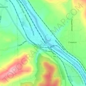
Name: Wampum topographic map, elevation, terrain.
Location: Wampum, Lawrence County, Pennsylvania, United States (40.87806 -80.34899 40.89934 -80.32144)
Average elevation: 274 m
Minimum elevation: 224 m
Maximum elevation: 364 m
Other topographic maps
Click on a map to view its topography, its elevation and its terrain.
West Pittsburg
United States > Pennsylvania > Lawrence County > Taylor Township
Average elevation: 279 m