
Make a donation
Gear up for your next adventure:
As an Amazon Associate, this site earns from qualifying purchases at no extra cost to you.
North Union Township topographic map
Click on the map to display elevation.
Make a donation
Gear up for your next adventure:
As an Amazon Associate, this site earns from qualifying purchases at no extra cost to you.
North Union Township
The eastern half of Union Township occupies the hilltops and western slope of Chestnut Ridge, with the highest elevation of 2,670 feet (810 m) located near the southeast corner of the township, just north of the Summit Hotel. The lowest point in the township is 910 feet (280 m) above sea level, along Redstone Creek where it exits the township from its northwestern corner.
Make a donation
Gear up for your next adventure:
As an Amazon Associate, this site earns from qualifying purchases at no extra cost to you.
About this map
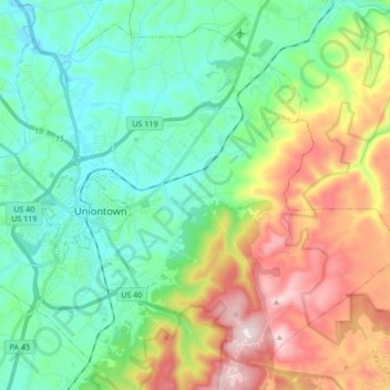
Name: North Union Township topographic map, elevation, terrain.
Average elevation: 447 m
Minimum elevation: 275 m
Maximum elevation: 815 m
Make a donation
Gear up for your next adventure:
As an Amazon Associate, this site earns from qualifying purchases at no extra cost to you.
Other topographic maps
Click on a map to view its topography, its elevation and its terrain.
Mill Run
United States > Pennsylvania > Fayette County > Springfield Township
Average elevation: 482 m