
Downingtown topographic map
Click on the map to display elevation.
About this map
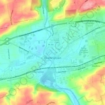
Name: Downingtown topographic map, elevation, terrain.
Location: Downingtown, Chester County, Pennsylvania, United States (39.99563 -75.72715 40.02138 -75.67572)
Average elevation: 106 m
Minimum elevation: 64 m
Maximum elevation: 181 m
Other topographic maps
Click on a map to view its topography, its elevation and its terrain.
Forestville
United States > Pennsylvania > Chester County > Upper Oxford Township
Average elevation: 150 m
Baptist Hill
United States > Pennsylvania > Chester County > Tredyffrin Township
Average elevation: 102 m