
Confluence topographic map
Click on the map to display elevation.
About this map
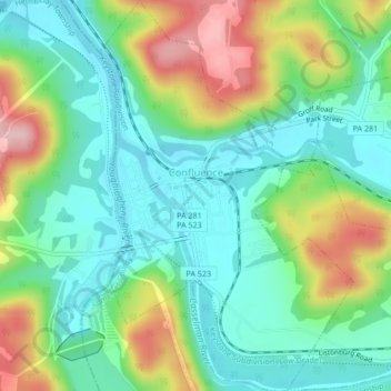
Name: Confluence topographic map, elevation, terrain.
Location: Confluence, Somerset County, Pennsylvania, United States (39.79463 -79.36717 39.82716 -79.33959)
Average elevation: 459 m
Minimum elevation: 393 m
Maximum elevation: 593 m
Other topographic maps
Click on a map to view its topography, its elevation and its terrain.
Mount Davis
United States > Pennsylvania > Somerset County > Elk Lick Township
Mount Davis has a humid continental climate that is affected by the high elevation significantly enough that the area feels slightly more like a cooler version of the climate zone during the winter months. Due to its high elevation, the area is colder much of the winter than Altoona, Johnstown, or State…
Average elevation: 908 m