
Topton topographic map
Click on the map to display elevation.
About this map
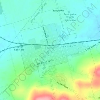
Name: Topton topographic map, elevation, terrain.
Location: Topton, Berks County, Pennsylvania, United States (40.49535 -75.71209 40.51011 -75.68951)
Average elevation: 161 m
Minimum elevation: 131 m
Maximum elevation: 243 m
Other topographic maps
Click on a map to view its topography, its elevation and its terrain.
Dale
United States > Pennsylvania > Berks County > Washington Township > Dale
Average elevation: 236 m