
Mackenzie River topographic map
Click on the map to display elevation.
Mackenzie River
The Mackenzie widens considerably to about 6 to 7 kilometres (3.7 to 4.3 mi) at Norman Wells, a major centre of oil production. There is a narrows at the Mountain River confluence called the Sans Sault Rapids, where the Mackenzie falls about 6 metres (20 ft). Below the Mountain River the Mackenzie flows due north until reaching The Ramparts, a limestone gorge barely 500 metres (1,600 ft) wide and up to 45 metres (148 ft) deep. Below The Ramparts is the village of Fort Good Hope, where the Mackenzie turns northwest again, soon crossing the Arctic Circle. The Mackenzie here flows slightly lower in elevation than the surrounding tundra, as a braided river between low bluffs about 3 to 5 kilometres (1.9 to 3.1 mi) apart. It receives the Arctic Red River from the southwest at Tsiigehtchic, where traffic on the Dempster Highway crosses via ferry/ice bridge.
About this map
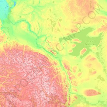
Name: Mackenzie River topographic map, elevation, terrain.
Location: Mackenzie River, Canada (61.02172 -136.56312 69.37357 -116.50000)
Average elevation: 655 m
Minimum elevation: -3 m
Maximum elevation: 4,873 m
Canada trails, hiking, mountain biking, running and outdoor activities
Other topographic maps
Click on a map to view its topography, its elevation and its terrain.
Toronto
Despite its deep ravines, Toronto is not remarkably hilly, but its elevation does increase steadily away from the lake. Elevation differences range from 76.5 metres (251 ft) above sea level at the Lake Ontario shore to 209 m (686 ft) ASL near the York University grounds in the city's north end at the…
Average elevation: 113 m
London
Canada > Ontario > London > London
London has a humid continental climate (Köppen Dfb), though due to its downwind location relative to Lake Huron and elevation changes across the city, it is virtually on the Dfa/Dfb (hot summer) boundary favouring the former climate zone to the southwest of the confluence of the South and North Thames Rivers,…
Average elevation: 268 m
Banff
Canada > Alberta > Banff > Banff
Banff is a town within Banff National Park in Alberta, Canada. It is located in Alberta's Rockies along the Trans-Canada Highway, approximately 126 km (78 mi) west of Calgary and 58 km (36 mi) east of Lake Louise. At 1,400 to 1,630 m (4,590 to 5,350 ft) above sea level, Banff is the community with the second…
Average elevation: 1,615 m
Guelph
This region of Ontario has cold winters and warm, humid summers, falling into the Köppen climate classification Dfb zone, with moderately high rainfall and snowfall. It is generally a couple of degrees cooler than lower elevation regions on the Great Lakes shorelines, especially so in winter, the exception…
Average elevation: 344 m
Grande Prairie
Canada > Alberta > Grande Prairie
Grande Prairie is located just north of the 55th parallel north, and is 465 km (289 mi) northwest of Edmonton, lying at an elevation of 669 m (2,195 ft) above sea level. The city is surrounded by farmland to the north, east, and west. To the south lies a vast boreal forest with aspen, tamarack, lodgepole pine,…
Average elevation: 668 m
Lethbridge
Canada > Alberta > Lethbridge
Its high elevation of 929 m (3,047.9 ft) and close proximity to the Rocky Mountains provides Lethbridge with cooler summers than other locations in the Canadian Prairies. These factors protect the city from strong northwest and southwest winds and contribute to frequent chinook winds during the winter.…
Average elevation: 918 m
Mount Royal
Canada > Quebec > Urban agglomeration of Montreal > Montreal
The hill is part of the Monteregian Hills situated between the Laurentians and the Appalachian Mountains. It gave its Latin name, Mons Regius, to the Monteregian chain. The hill consists of three peaks: Colline de la Croix (or Mont Royal proper) at 233 m (764 ft), Colline d'Outremont (or Mount Murray, in the…
Average elevation: 111 m
Langley Township
Canada > British Columbia > Metro Vancouver Regional District > Township of Langley > Langley Township
Average elevation: 37 m
Avalon Peninsula
Canada > Newfoundland and Labrador > Spaniard's Bay > Tilton
Average elevation: 157 m
Prince George
Canada > British Columbia > Regional District of Fraser-Fort George > Prince George
Average elevation: 708 m
Richmond
Canada > British Columbia > Metro Vancouver Regional District > Richmond
Average elevation: 15 m
Poplarfield
Canada > Manitoba > Division No. 18 > Rural Municipality of Fisher
Average elevation: 270 m
Key Harbour
Canada > Ontario > Parry Sound District > Unorganized Centre Parry Sound
Average elevation: 178 m
Hope
Canada > British Columbia > Fraser Valley Regional District > Hope > Hope
Average elevation: 435 m
Eagle Bay
Canada > British Columbia > Columbia-Shuswap Regional District > Area C (Blind Bay/Sorrento)
Average elevation: 497 m
Nose Hill Park
Names currently associated with topographical features in and near Nose Hill Park reflect the impact of the European newcomers and European trade goods on the Peigan. For example, Spy Hill, the westward extension of Nose Hill, derived its present name from the aboriginal practice of communicating with distant…
Average elevation: 1,174 m
70 Mile House
Canada > British Columbia > Thompson-Nicola Regional District > Area E (Bonaparte Plateau)
Average elevation: 1,087 m
Mara Lake
Canada > British Columbia > Columbia-Shuswap Regional District > Area E (Eagle River Valley) > Swansea Point
The lake is 35.3 kilometres (21.9 mi) long. The surface area is about 1,943 hectares (4,800 acres) and elevation is 338 metres (1,109 ft) above sea level. The mean and maximum depth is 18 metres (59 ft).
Average elevation: 826 m
Canmore
Canada > Alberta > Town of Canmore
Elevation Place opened in April 2013 as Canmore's new recreation facility. Construction of the facility began in 2012 to replace the Canmore Recreation Centre (the community's old facility). The facility offers an 8-lane 25m lap pool, a world class climbing wall developed by Walltopia, two cardio rooms, a…
Average elevation: 1,565 m
Nanoose Bay
Canada > British Columbia > Regional District of Nanaimo > Area E (Nanoose Bay)
Average elevation: 58 m
Anglemont
Canada > British Columbia > Columbia-Shuswap Regional District > Area F (Scotch Creek/Seymour Arm)
Average elevation: 472 m
Peterborough
Canada > Ontario > Peterborough
Peterborough's topography is largely defined by land formations created by the receding Wisconsian glaciers 10,000–15,000 years ago. The South End and Downtown portions of the City sit on what was the bottom of the glacial Lake Peterborough—part of a glacial spillway created when glacial meltwaters from…
Average elevation: 235 m
Laurentian Mountains
One of Quebec's official regions is called Laurentides. The mountain range runs through four other regions; Capitale-Nationale, Outaouais, Lanaudière, and Mauricie. The elevation generally ranges from around 500 m (1,640 ft) to 1,000 m (3,280 ft) with Mont Raoul-Blanchard being its highest peak, at 1,166 m…
Average elevation: 348 m
Saint-Pierre de Wakefield
Canada > Quebec > Les Collines-de-l'Outaouais > Val-des-Monts
Average elevation: 224 m
Upsala
Canada > Ontario > Thunder Bay District > Unorganized Thunder Bay District
Average elevation: 487 m
Fire Mountain
Canada > British Columbia > Thompson-Nicola Regional District > Area A (Wells Gray Country)
Kostal Cone, also called Kostal Volcano and Fire Mountain, is a young cinder cone in Wells Gray Provincial Park in east-central British Columbia, Canada. It rises from the northeast shore of Kostal Lake in the Cariboo Mountains. With an elevation of 1,440 m (4,724 ft), Kostal Cone is one of the lowest…
Average elevation: 1,316 m
Ara Lake
Canada > Ontario > Thunder Bay District > Unorganized Thunder Bay District
Average elevation: 308 m
Vedder River
Canada > British Columbia > Fraser Valley Regional District > Chilliwack
Average elevation: 110 m
Kamloops
Canada > British Columbia > Thompson-Nicola Regional District > Kamloops
Average elevation: 875 m
Aldergrove Regional Park
Canada > British Columbia > Metro Vancouver Regional District > Township of Langley
Average elevation: 64 m
Anahim Lake
Canada > British Columbia > Cariboo Regional District > Area J (West Chilcotin)
Average elevation: 1,101 m