Geolocate

Simcoe topographic map

Click on the map to display elevation.

About this map

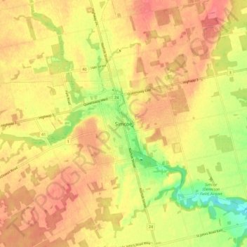
Name: Simcoe topographic map, elevation, terrain.

Location: Simcoe, Norfolk County, Ontario, N3Y 2E5, Canada (42.79724 -80.34391 42.87724 -80.26391)

Average elevation: 227 m

Minimum elevation: 188 m

Maximum elevation: 249 m

Norfolk County trails, hiking, mountain biking, running and outdoor activities

Other topographic maps

Click on a map to view its topography, its elevation and its terrain.

Deer Creek

Canada > Ontario > Norfolk County

Average elevation: 215 m

Deer Creek

Canada > Ontario > Norfolk County > Langton

Average elevation: 226 m

Bass Lake

Canada > Ontario > Norfolk County > Waterford

Average elevation: 236 m

Port Dover Beach

Canada > Ontario > Norfolk County > Port Dover

Average elevation: 180 m

Haldimand—Norfolk

Canada > Ontario > Norfolk County

Average elevation: 210 m

Haldimand—Norfolk

Canada > Ontario > Norfolk County

Average elevation: 210 m

Gear up for your next adventure:

🧥Packable Rain Jacket - Breathable waterproof layer for unpredictable weather
🔭Outdoor Binoculars - Lightweight binoculars for birdwatching and hiking
📷Outdoor Action Camera - Capture high-elevation views and rugged adventures
🕯️Camping Lantern - Illuminates your entire campsite with high-efficiency LEDs
🚲Bike Repair Kit - Essential tools for on-trail mechanical issues

As an Amazon Associate, this site earns from qualifying purchases at no extra cost to you.