
Iron Bridge topographic map
Click on the map to display elevation.
About this map
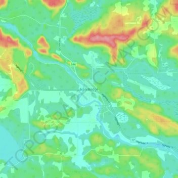
Name: Iron Bridge topographic map, elevation, terrain.
Average elevation: 200 m
Minimum elevation: 172 m
Maximum elevation: 270 m
Algoma District trails, hiking, mountain biking, running and outdoor activities
Other topographic maps
Click on a map to view its topography, its elevation and its terrain.
Kabinakagami Lake
Canada > Ontario > Algoma District > Unorganized North Algoma
Average elevation: 332 m
St. Joseph Island
Canada > Ontario > Algoma District > Jocelyn Township
Its highest point, known colloquially and by surveyors as "the Mountain", is near the centre of the island near Carterton with an elevation of 345.6 m, which is about 169 m above Lake Huron.
Average elevation: 196 m
Lucille Lake;Wood Creek
Canada > Ontario > Algoma District > Unorganized North Algoma
Average elevation: 441 m
Kirkpatrick Lake
Canada > Ontario > Algoma District > Unorganized North Algoma
Average elevation: 429 m
Kimiwan Creek;Kimiwan Lakes
Canada > Ontario > Algoma District > Unorganized North Algoma
Average elevation: 442 m
Lauzon Lake
Canada > Ontario > Algoma District > The North Shore Township > Algoma Mills
Average elevation: 210 m
Montreal Island
Canada > Ontario > Algoma District > Unorganized North Algoma
Average elevation: 190 m
Kabinakagamisis Lake
Canada > Ontario > Algoma District > Unorganized North Algoma
Average elevation: 324 m
St. Joseph Island
Canada > Ontario > Algoma District > Jocelyn Township
Its highest point, known colloquially and by surveyors as "the Mountain", is near the centre of the island near Carterton with an elevation of 345.6 m, which is about 169 m above Lake Huron.
Average elevation: 196 m