Geolocate

Caledonia topographic map

Click on the map to display elevation.

About this map

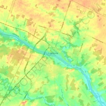
Name: Caledonia topographic map, elevation, terrain.

Location: Caledonia, Haldimand County, Ontario, N3W 1C1, Canada (43.03379 -79.99191 43.11379 -79.91191)

Average elevation: 204 m

Minimum elevation: 183 m

Maximum elevation: 220 m

Haldimand County trails, hiking, mountain biking, running and outdoor activities

Gear up for your next adventure:

🕯️Camping Lantern - Illuminates your entire campsite with high-efficiency LEDs
Bushcraft Tarp - Versatile emergency shelter or gear protection
🥾All-Terrain Hiking Boots - Versatile boots for varied hiking conditions
Backpacking Tent - Lightweight tent for long-distance hiking trips
Camping Tent - Weather-resistant tents suitable for 2 to 6 people

As an Amazon Associate, this site earns from qualifying purchases at no extra cost to you.