
Make a donation
Gear up for your next adventure:
As an Amazon Associate, this site earns from qualifying purchases at no extra cost to you.
Auckland Islands topographic map
Click on the map to display elevation.
Make a donation
Gear up for your next adventure:
As an Amazon Associate, this site earns from qualifying purchases at no extra cost to you.
Auckland Islands
The vegetation of the islands sub-divides into distinct altitudinal zones. Inland from the salt-spray zone, the fringes of the islands predominantly feature forests of southern rata Metrosideros umbellata, and in places the subantarctic tree daisy (Olearia lyallii), probably introduced by sealers. Above this exists a subalpine shrub zone dominated by Dracophyllum, Coprosma and Myrsine (with some rata). At higher elevations tussock grass and megaherb communities dominate the flora.
Make a donation
Gear up for your next adventure:
As an Amazon Associate, this site earns from qualifying purchases at no extra cost to you.
About this map
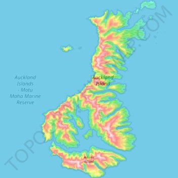
Name: Auckland Islands topographic map, elevation, terrain.
Location: Auckland Islands, New Zealand (-50.92883 165.86895 -50.48468 166.36220)
Average elevation: 51 m
Minimum elevation: -1 m
Maximum elevation: 640 m
Make a donation
Gear up for your next adventure:
As an Amazon Associate, this site earns from qualifying purchases at no extra cost to you.
Other topographic maps
Click on a map to view its topography, its elevation and its terrain.
Greymouth
New Zealand > West Coast > Grey District
A combination of high intensity rainfall, high topographic relief and short steep rivers often leads to rapid flooding of low-lying land across the West Coast. Since its founding Greymouth has experienced two dozen floods by the Grey River, with many of the most significant being assigned names: for example,…
Average elevation: 40 m
Make a donation
Gear up for your next adventure:
As an Amazon Associate, this site earns from qualifying purchases at no extra cost to you.
Make a donation
Gear up for your next adventure:
As an Amazon Associate, this site earns from qualifying purchases at no extra cost to you.
Make a donation
Gear up for your next adventure:
As an Amazon Associate, this site earns from qualifying purchases at no extra cost to you.
Reserve
New Zealand > Northland > Far North District > Bay of Islands-Whangaroa Community > Kerikeri
Average elevation: 56 m
Make a donation
Gear up for your next adventure:
As an Amazon Associate, this site earns from qualifying purchases at no extra cost to you.
Cape Kidnappers / Te Kauwae-a-Māui
New Zealand > Hawke's Bay > Hastings District
Average elevation: 16 m
Taumatawhakatangihangakōauauotamateapōkaiwhenuakitānatahu
New Zealand > Hawke's Bay > Central Hawke's Bay District
Average elevation: 199 m
Make a donation
Gear up for your next adventure:
As an Amazon Associate, this site earns from qualifying purchases at no extra cost to you.
Make a donation
Gear up for your next adventure:
As an Amazon Associate, this site earns from qualifying purchases at no extra cost to you.
Orepuki
New Zealand > Southland > Southland District > Tuatapere Te Waewae Community
Average elevation: 22 m
Make a donation
Gear up for your next adventure:
As an Amazon Associate, this site earns from qualifying purchases at no extra cost to you.
Make a donation
Gear up for your next adventure:
As an Amazon Associate, this site earns from qualifying purchases at no extra cost to you.
Russell
New Zealand > Northland > Far North District > Bay of Islands-Whangaroa Community
Average elevation: 12 m
Make a donation
Gear up for your next adventure:
As an Amazon Associate, this site earns from qualifying purchases at no extra cost to you.
Make a donation
Gear up for your next adventure:
As an Amazon Associate, this site earns from qualifying purchases at no extra cost to you.
Make a donation
Gear up for your next adventure:
As an Amazon Associate, this site earns from qualifying purchases at no extra cost to you.
Saint Peters
New Zealand > Northland > Far North District > Bay of Islands-Whangaroa Community
Average elevation: 46 m
Victoria Clock Tower
New Zealand > Canterbury > Christchurch City > Linwood-Central-Heathcote Community
Average elevation: 11 m
Make a donation
Gear up for your next adventure:
As an Amazon Associate, this site earns from qualifying purchases at no extra cost to you.
Make a donation
Gear up for your next adventure:
As an Amazon Associate, this site earns from qualifying purchases at no extra cost to you.
Make a donation
Gear up for your next adventure:
As an Amazon Associate, this site earns from qualifying purchases at no extra cost to you.