Geolocate

Upper Hutt topographic map

Click on the map to display elevation.

About this map

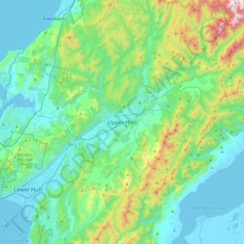
Name: Upper Hutt topographic map, elevation, terrain.

Location: Upper Hutt, Upper Hutt City, Wellington, 5218, New Zealand (-41.28407 174.90996 -40.96407 175.22996)

Average elevation: 271 m

Minimum elevation: -3 m

Maximum elevation: 1,353 m

Gear up for your next adventure:

🧼Travel Hand Sanitizer - Keep hands clean when water is scarce
Tent Footprint - Protect tent floor and increase durability
🥾Trail Running Boots - Durable shoes designed for trail running
🔦LED Headlamp - Hands-free lighting for early morning starts or late finishes
🛶Canoe Life Vest - Safety vest for water sports

As an Amazon Associate, this site earns from qualifying purchases at no extra cost to you.