
Cardrona topographic map
Click on the map to display elevation.
About this map
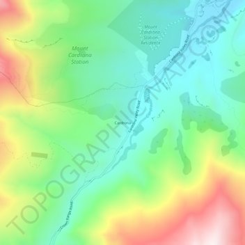
Name: Cardrona topographic map, elevation, terrain.
Location: Cardrona, Queenstown-Lakes District, Otago, New Zealand (-44.90327 168.98057 -44.86327 169.02057)
Average elevation: 758 m
Minimum elevation: 497 m
Maximum elevation: 1,256 m
Other topographic maps
Click on a map to view its topography, its elevation and its terrain.
Lake Hāwea
New Zealand > Otago > Queenstown-Lakes District
Lake Hāwea is New Zealand's ninth largest lake located on the South Island in the Otago Region at an altitude of 348 m. It covers 141 km2 and is 392 m deep.
Average elevation: 864 m