Geolocate

Geraldine topographic map

Click on the map to display elevation.

About this map

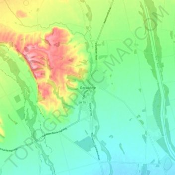
Name: Geraldine topographic map, elevation, terrain.

Location: Geraldine, Timaru District, Canterbury, 7930, New Zealand (-44.13210 171.20259 -44.05210 171.28259)

Average elevation: 130 m

Minimum elevation: 78 m

Maximum elevation: 243 m

Gear up for your next adventure:

🧴Bear Spray Holster - Quick-access carry for essential Canadian wilderness safety
🏃Hydration Running Vest - Carry water and maps close to your body for speed
🔥Emergency Fire Starter - Reliable ignition source for all weather conditions
Tent Footprint - Protect tent floor and increase durability
Camping Groundsheet - Protect your tent from moisture and dirt

As an Amazon Associate, this site earns from qualifying purchases at no extra cost to you.