Geolocate

Richmond topographic map

Click on the map to display elevation.

About this map

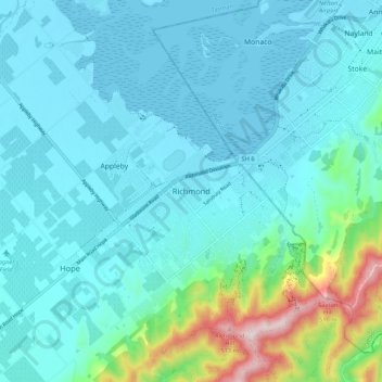
Name: Richmond topographic map, elevation, terrain.

Location: Richmond, Tasman, 7020, New Zealand (-41.37810 173.14723 -41.29810 173.22723)

Average elevation: 83 m

Minimum elevation: -1 m

Maximum elevation: 551 m

Other topographic maps

Click on a map to view its topography, its elevation and its terrain.

Rolling River

New Zealand > Tasman

Average elevation: 539 m

Gear up for your next adventure:

🏃Hydration Running Vest - Carry water and maps close to your body for speed
📷Outdoor Action Camera - Capture high-elevation views and rugged adventures
🧦Hiking Socks - Moisture-wicking and comfortable socks for long hikes
🏕️Camping Hammock - Integrated protection for sleeping between trees
🥾Waterproof Hiking Shoes - Durable shoes for wet and rugged trails

As an Amazon Associate, this site earns from qualifying purchases at no extra cost to you.