Geolocate

Russell topographic map

Click on the map to display elevation.

About this map

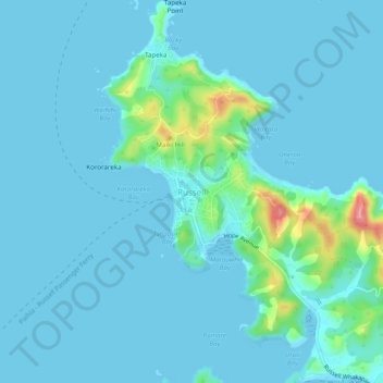
Name: Russell topographic map, elevation, terrain.

Location: Russell, Bay of Islands-Whangaroa Community, Far North District, Northland, 0202, New Zealand (-35.28127 174.10365 -35.24127 174.14365)

Average elevation: 12 m

Minimum elevation: -1 m

Maximum elevation: 110 m

Other topographic maps

Click on a map to view its topography, its elevation and its terrain.

Gear up for your next adventure:

🔭Compact Monocular - One-handed bird watching and trail spotting
🕶️Polarized Sunglasses - Reduces glare from snow and water at high elevations
🧴Sunscreen SPF - Broad-spectrum sunscreen for outdoor activities
🧦Hiking Socks - Moisture-wicking and comfortable socks for long hikes
🏕️Camping Hammock - Integrated protection for sleeping between trees

As an Amazon Associate, this site earns from qualifying purchases at no extra cost to you.