
Make a donation
Gear up for your next adventure:
As an Amazon Associate, this site earns from qualifying purchases at no extra cost to you.
Crown Island topographic map
Click on the map to display elevation.
Make a donation
Gear up for your next adventure:
As an Amazon Associate, this site earns from qualifying purchases at no extra cost to you.
About this map
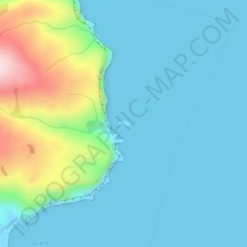
Name: Crown Island topographic map, elevation, terrain.
Location: Crown Island, Akaroa, Canterbury, New Zealand (-43.79550 173.11304 -43.79492 173.11485)
Average elevation: 69 m
Minimum elevation: -1 m
Maximum elevation: 350 m
Make a donation
Gear up for your next adventure:
As an Amazon Associate, this site earns from qualifying purchases at no extra cost to you.
Other topographic maps
Click on a map to view its topography, its elevation and its terrain.
Make a donation
Gear up for your next adventure:
As an Amazon Associate, this site earns from qualifying purchases at no extra cost to you.
Kaikōura
The Hutton's shearwater (Puffinus huttoni) or Kaikōura tītī is an endangered seabird in the family Procellariidae. It is found in waters around Australia and New Zealand but it only breeds in the Seaward Kaikōura Range in New Zealand. It is the only seabird in the world that breeds in an alpine…
Average elevation: 530 m
Make a donation
Gear up for your next adventure:
As an Amazon Associate, this site earns from qualifying purchases at no extra cost to you.
Victoria Clock Tower
New Zealand > Canterbury > Christchurch City > Linwood-Central-Heathcote Community
Average elevation: 11 m
Make a donation
Gear up for your next adventure:
As an Amazon Associate, this site earns from qualifying purchases at no extra cost to you.
Halswell-Hornby-Riccarton Community
New Zealand > Canterbury > Christchurch City
Average elevation: 49 m