
Tubará topographic map
Click on the map to display elevation.
About this map
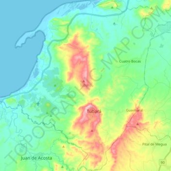
Name: Tubará topographic map, elevation, terrain.
Location: Tubará, Atlántico, RAP Caribe, Colombia (10.81635 -75.07516 10.98158 -74.91827)
Average elevation: 84 m
Minimum elevation: -1 m
Maximum elevation: 337 m
Other topographic maps
Click on a map to view its topography, its elevation and its terrain.
Barranquilla
Colombia > Atlántico > Barranquilla > Barranquilla
El sistema de alcantarillado de la ciudad es subterráneo y único. Las redes de drenaje conducen las aguas residuales en forma paralela a la red de agua potable hacia los cuerpos de agua sin recibir ningún tipo de tratamiento. De acuerdo con la topografía de Barranquilla, el alcantarillado de la ciudad se…
Average elevation: 27 m
Puerto Colombia
Colombia > Atlántico > Puerto Colombia
Puerto Colombia forma parte del Área Metropolitana de Barranquilla, está ubicada en las coordenadas geográficas 10°59′2″ de latitud Norte y a 74º 57' 2" de longitud Oeste, con una altitud promedio de 15 m s. n. m., a una distancia de 15 kilómetros de Barranquilla, capital del departamento. Su…
Average elevation: 32 m
Parque Santander
Colombia > Atlántico > Barranquilla > Perímetro Urbano Barranquilla
Average elevation: 39 m
Bulevar de Simón Bolívar
Colombia > Atlántico > Barranquilla > Perímetro Urbano Barranquilla
Average elevation: 21 m
Repelón
Colombia > Atlántico > Repelón
Repelón es un municipio del departamento del Atlántico, Colombia. Se encuentra al sudoeste del departamento marcando límites con el departamento de Bolívar. Fue fundado por Hilario Berrío el 25 de octubre de 1848. Su altitud es de 9 m s. n. m., temperatura promedio anual de 28 grados, tiene 350 km² y 86…
Average elevation: 40 m
Parque La Solución
Colombia > Atlántico > Barranquilla > Perímetro Urbano Barranquilla
Average elevation: 31 m
Tubará
Tubará presenta diferentes atractivos turísticos como sitios naturales, históricos y arqueológicos, playas y miradores, dada su topografía escarpada. Varios corregimientos y veredas aledaños son ideales para el ecoturismo y el senderismo, como Juaruco, El Morro y el Corral de San Luis.
Average elevation: 142 m
Parque Montecristo
Colombia > Atlántico > Barranquilla > Perímetro Urbano Barranquilla
Average elevation: 20 m
Parque San Salvador
Colombia > Atlántico > Barranquilla > Perímetro Urbano Barranquilla
Average elevation: 23 m
Reserva Natural de la Sociedad Civil Los Charcones
Average elevation: 218 m
Ponedera
Colombia > Atlántico > Ponedera
Con una altura de 10 m s. n. m. , es propicio encontrar una topografía plana y ondulada, con un suelo mixto, arcilloso y arenoso; también encharcamientos en época de lluvia. Gracias a sus características climáticas y topográficas el municipio es un sitio apto para cultivos transitorios, permanentes y…
Average elevation: 12 m
Parque San Pio
Colombia > Atlántico > Barranquilla > Perímetro Urbano Barranquilla
Average elevation: 51 m
Ponedera
Colombia > Atlántico > Ponedera
Con una altura de 10 m s. n. m. , es propicio encontrar una topografía plana y ondulada, con un suelo mixto, arcilloso y arenoso; también encharcamientos en época de lluvia. Gracias a sus características climáticas y topográficas el municipio es un sitio apto para cultivos transitorios, permanentes y…
Average elevation: 12 m
Pital de Megua
Colombia > Atlántico > Baranoa
La cobertura vegetal que presenta el territorio pitalero se conoce como bosque seco tropical (Bs-t)y que se encuentra entre los 12 y 150 m de altitud con temperaturas superiores a los 24 °C (piso térmico cálido) y precipitaciones entre los 700 y 2000 mm anuales, con dos períodos uno seco y otro lluvioso.…
Average elevation: 147 m
Puerto Colombia
Colombia > Atlántico > Puerto Colombia
Puerto Colombia forma parte del Área Metropolitana de Barranquilla, está ubicada en las coordenadas geográficas 10°59′2″ de latitud Norte y a 74º 57' 2" de longitud Oeste, con una altitud promedio de 15 m s. n. m., a una distancia de 15 kilómetros de Barranquilla, capital del departamento. Su…
Average elevation: 32 m