Geolocate

Salinas del Rey topographic map

Click on the map to display elevation.

👉 Easily get elevation data in JSON, GeoTIFF and KML formats using Elevation API
Thank you for supporting this site ❤️
Make a donation

About this map

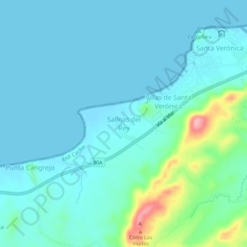
Name: Salinas del Rey topographic map, elevation, terrain.

Location: Salinas del Rey, Juan de Acosta, Atlántico, Colombia (10.85111 -75.11359 10.89111 -75.07359)

Average elevation: 23 m

Minimum elevation: -1 m

Maximum elevation: 145 m

Other topographic maps

Click on a map to view its topography, its elevation and its terrain.

Saco

Colombia > Atlántico > Juan de Acosta

Average elevation: 80 m

Saco

Colombia > Atlántico > Juan de Acosta

Average elevation: 80 m

Gear up for your next adventure:

🧦Crew Hiking Socks - Comfortable socks for long-distance hikes
👟Sport Hiking Sandals - Breathable footwear for water crossings and camp rest
🧴Sunscreen SPF - Broad-spectrum sunscreen for outdoor activities
🥾Approach Boots - Comfortable boots for hiking and climbing approaches
🥾Trekking Poles - Adjustable trekking poles to reduce knee stress and improve stability

As an Amazon Associate, this site earns from qualifying purchases at no extra cost to you.