
Ponedera topographic map
Click on the map to display elevation.
Ponedera
Con una altura de 10 m s. n. m. , es propicio encontrar una topografía plana y ondulada, con un suelo mixto, arcilloso y arenoso; también encharcamientos en época de lluvia. Gracias a sus características climáticas y topográficas el municipio es un sitio apto para cultivos transitorios, permanentes y semipermanentes, siendo así una vía al desarrollo.
About this map
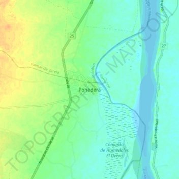
Name: Ponedera topographic map, elevation, terrain.
Location: Ponedera, Atlántico, Colombia (10.59960 -74.79017 10.67960 -74.71017)
Average elevation: 12 m
Minimum elevation: 2 m
Maximum elevation: 30 m