
Make a donation
Gear up for your next adventure:
As an Amazon Associate, this site earns from qualifying purchases at no extra cost to you.
Tubará topographic map
Click on the map to display elevation.
Make a donation
Gear up for your next adventure:
As an Amazon Associate, this site earns from qualifying purchases at no extra cost to you.
Tubará
Tubará presenta diferentes atractivos turísticos como sitios naturales, históricos y arqueológicos, playas y miradores, dada su topografía escarpada. Varios corregimientos y veredas aledaños son ideales para el ecoturismo y el senderismo, como Juaruco, El Morro y el Corral de San Luis.
Make a donation
Gear up for your next adventure:
As an Amazon Associate, this site earns from qualifying purchases at no extra cost to you.
About this map
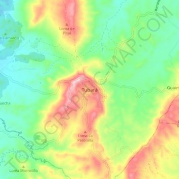
Name: Tubará topographic map, elevation, terrain.
Location: Tubará, Atlántico, Colombia (10.83408 -75.01794 10.91408 -74.93794)
Average elevation: 142 m
Minimum elevation: 23 m
Maximum elevation: 337 m
Make a donation
Gear up for your next adventure:
As an Amazon Associate, this site earns from qualifying purchases at no extra cost to you.
Other topographic maps
Click on a map to view its topography, its elevation and its terrain.