
Repelón topographic map
Click on the map to display elevation.
Repelón
Repelón es un municipio del departamento del Atlántico, Colombia. Se encuentra al sudoeste del departamento marcando límites con el departamento de Bolívar. Fue fundado por Hilario Berrío el 25 de octubre de 1848. Su altitud es de 9 m s. n. m., temperatura promedio anual de 28 grados, tiene 350 km² y 86 km lo separan de Barranquilla, capital del departamento del Atlántico.
About this map
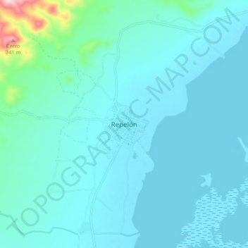
Name: Repelón topographic map, elevation, terrain.
Location: Repelón, Atlántico, Colombia (10.45501 -75.16448 10.53501 -75.08448)
Average elevation: 40 m
Minimum elevation: 1 m
Maximum elevation: 382 m
Other topographic maps
Click on a map to view its topography, its elevation and its terrain.