
Juaruco topographic map
Click on the map to display elevation.
About this map
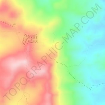
Name: Juaruco topographic map, elevation, terrain.
Location: Juaruco, Tubará, Atlántico, RAP Caribe, Colombia (10.92704 -74.98636 10.93142 -74.98334)
Average elevation: 176 m
Minimum elevation: 50 m
Maximum elevation: 300 m
Other topographic maps
Click on a map to view its topography, its elevation and its terrain.
Tubará
Tubará presenta diferentes atractivos turísticos como sitios naturales, históricos y arqueológicos, playas y miradores, dada su topografía escarpada. Varios corregimientos y veredas aledaños son ideales para el ecoturismo y el senderismo, como Juaruco, El Morro y el Corral de San Luis.
Average elevation: 142 m