Geolocate

Santa Cruz topographic map

Click on the map to display elevation.

About this map

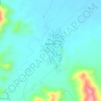
Name: Santa Cruz topographic map, elevation, terrain.

Location: Santa Cruz, Luruaco, Atlántico, Caribe, Colombia (10.56630 -75.21714 10.57882 -75.21042)

Average elevation: 83 m

Minimum elevation: 52 m

Maximum elevation: 205 m

Gear up for your next adventure:

🥾Trekking Poles - Adjustable trekking poles to reduce knee stress and improve stability
🥾Mountain Hiking Boots - High-traction boots for rocky terrain
🧦Thermal Socks - Warm socks for winter hiking or camping
🛌Insulated Sleeping Pad - Critical thermal barrier between you and the cold ground
🥾Lightweight Hiking Shoes - Comfortable shoes for day hikes

As an Amazon Associate, this site earns from qualifying purchases at no extra cost to you.