
Make a donation
Gear up for your next adventure:
As an Amazon Associate, this site earns from qualifying purchases at no extra cost to you.
Basilicata topographic map
Click on the map to display elevation.
Make a donation
Gear up for your next adventure:
As an Amazon Associate, this site earns from qualifying purchases at no extra cost to you.
About this map
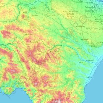
Name: Basilicata topographic map, elevation, terrain.
Location: Basilicata, Italy (39.89581 15.33497 41.14090 16.86704)
Average elevation: 485 m
Minimum elevation: -1 m
Maximum elevation: 2,186 m
Make a donation
Gear up for your next adventure:
As an Amazon Associate, this site earns from qualifying purchases at no extra cost to you.
Other topographic maps
Click on a map to view its topography, its elevation and its terrain.
Mesiano
Italy > Trentino-Alto Adige/Südtirol > Provincia di Trento > Trento > Povo
Average elevation: 353 m
Make a donation
Gear up for your next adventure:
As an Amazon Associate, this site earns from qualifying purchases at no extra cost to you.
Torre Grande
Italy > Sardinia > Aristanis/Oristano > Aristanis/Oristano > Torregrande
Average elevation: 1 m
Eisacktal - Valle Isarco
Italy > Trentino-Alto Adige/Südtirol > South Tyrol
Average elevation: 1,487 m
Mount Etna
During the first 1500 years AD, many eruptions went unrecorded (or records have been lost); among the more significant are: (1) an eruption in about 1030 AD near Monte Ilice on the lower southeast flank, which produced a lava flow that travelled about 10 km, reaching the sea north of Acireale; the villages of…
Average elevation: 1,157 m
Make a donation
Gear up for your next adventure:
As an Amazon Associate, this site earns from qualifying purchases at no extra cost to you.
Make a donation
Gear up for your next adventure:
As an Amazon Associate, this site earns from qualifying purchases at no extra cost to you.
Pens - Pennes
Italy > Trentino-Alto Adige/Südtirol > South Tyrol > Sarntal - Sarentino
Average elevation: 1,850 m
Bologna
Italy > Emilia-Romagna > Bologna > Bologna
Bologna is situated on the edge of the Po Plain at the foot of the Apennine Mountains, at the meeting of the Reno and Savena river valleys. As Bologna's two main watercourses flow directly to the sea, the town lies outside of the drainage basin of the River Po. The Province of Bologna stretches from the…
Average elevation: 118 m
Make a donation
Gear up for your next adventure:
As an Amazon Associate, this site earns from qualifying purchases at no extra cost to you.
Cima Palon
Italy > Trentino-Alto Adige/Südtirol > Provincia di Trento
Cima Palon, also called Monte Pasubio, is the highest peak of the Pasubio group of Little Dolomites in Veneto, Italy. It has an elevation of 2,239 metres.
Average elevation: 1,896 m
Make a donation
Gear up for your next adventure:
As an Amazon Associate, this site earns from qualifying purchases at no extra cost to you.
Make a donation
Gear up for your next adventure:
As an Amazon Associate, this site earns from qualifying purchases at no extra cost to you.
Val del Tof Larch
Italy > Trentino – Alto Adige/Südtirol > Provincia di Trento > Spormaggiore > Fabbrica
Average elevation: 790 m
Make a donation
Gear up for your next adventure:
As an Amazon Associate, this site earns from qualifying purchases at no extra cost to you.
Sistiana / Sesljan
Italy > Friuli – Venezia Giulia > Trieste > Duino Aurisina / Devin - Nabrežina
The village lies northwest of Trieste, the provincial capital. The closest airport is located 7 nm west of Sistiana. Average altitude: 70 m above sea level. Sistiana is on time zone UTC +1 (+2DT).
Average elevation: 92 m
Make a donation
Gear up for your next adventure:
As an Amazon Associate, this site earns from qualifying purchases at no extra cost to you.
Make a donation
Gear up for your next adventure:
As an Amazon Associate, this site earns from qualifying purchases at no extra cost to you.
Naples
Italy > Campania > Napoli > Naples
The city is situated on the Gulf of Naples, on the western coast of southern Italy; it rises from sea level to an elevation of 450 metres (1,480 ft). The small rivers which formerly crossed the centre of the city have since been covered over by construction. It lies between two notable volcanic regions, Mount…
Average elevation: 58 m
Campo Imperatore
Italy > Abruzzo > L'Aquila > L'Aquila
The plateau's altitude ranges from 1,500 to 1,900 meters. It covers an expanse of approximately 80 km2. Campo Imperatore is home to one of Italy's oldest alpine ski resorts. Located on the plateau's western edge, the resort began commercial operation in the 1920s and continues to thrive as a ski resort to this…
Average elevation: 2,056 m
Make a donation
Gear up for your next adventure:
As an Amazon Associate, this site earns from qualifying purchases at no extra cost to you.
Make a donation
Gear up for your next adventure:
As an Amazon Associate, this site earns from qualifying purchases at no extra cost to you.
Etsch - Adige
Italy > Trentino-Alto Adige/Südtirol > South Tyrol > Tarnell - Tarnello > Oberplatz
Average elevation: 1,075 m
Make a donation
Gear up for your next adventure:
As an Amazon Associate, this site earns from qualifying purchases at no extra cost to you.
Canazei
Italy > Trentino-Alto Adige/Südtirol > Provincia di Trento > Canazei > Canazei
Average elevation: 1,823 m
Make a donation
Gear up for your next adventure:
As an Amazon Associate, this site earns from qualifying purchases at no extra cost to you.
Sëlva - Wolkenstein - Selva
Italy > Trentino-Alto Adige/Südtirol > South Tyrol > Sëlva - Wolkenstein - Selva di Val Gardena
Average elevation: 1,828 m
Make a donation
Gear up for your next adventure:
As an Amazon Associate, this site earns from qualifying purchases at no extra cost to you.
Make a donation
Gear up for your next adventure:
As an Amazon Associate, this site earns from qualifying purchases at no extra cost to you.
Make a donation
Gear up for your next adventure:
As an Amazon Associate, this site earns from qualifying purchases at no extra cost to you.
Klettergarten Hohe Festung (Franzenfeste)
Italy > Trentino-Alto Adige/Südtirol > South Tyrol > Franzensfeste - Fortezza > Obersalcher
Average elevation: 1,048 m
Viums - Fiumes
Italy > Trentino-Alto Adige/Südtirol > South Tyrol > Natz-Schabs - Naz-Sciaves
Average elevation: 847 m
Make a donation
Gear up for your next adventure:
As an Amazon Associate, this site earns from qualifying purchases at no extra cost to you.
Fleins - Lines
Italy > Trentino-Alto Adige/Südtirol > South Tyrol > Freienfeld - Campo di Trens > Mauls - Mules
Average elevation: 1,367 m
Make a donation
Gear up for your next adventure:
As an Amazon Associate, this site earns from qualifying purchases at no extra cost to you.
Rolle Pass
Italy > Trentino-Alto Adige/Südtirol > Provincia di Trento > San Martino di Castrozza
Average elevation: 1,996 m
Make a donation
Gear up for your next adventure:
As an Amazon Associate, this site earns from qualifying purchases at no extra cost to you.
Make a donation
Gear up for your next adventure:
As an Amazon Associate, this site earns from qualifying purchases at no extra cost to you.
Make a donation
Gear up for your next adventure:
As an Amazon Associate, this site earns from qualifying purchases at no extra cost to you.
Salina di Sant'Antioco
Italy > Sardinia > Santu Giuanni Suèrgiu/San Giovanni Suergiu
Average elevation: 0 m
Borgo Mieli
Italy > Friuli-Venezia Giulia > Pordenone > Fanna > Fanna > Borgo Mieli
Average elevation: 366 m
Make a donation
Gear up for your next adventure:
As an Amazon Associate, this site earns from qualifying purchases at no extra cost to you.
Make a donation
Gear up for your next adventure:
As an Amazon Associate, this site earns from qualifying purchases at no extra cost to you.