Geolocate

Pralongo topographic map

Interactive map

Click on the map to display elevation.

About this map

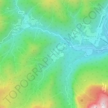
Name: Pralongo topographic map, elevation, terrain.

Location: Pralongo, Val di Zoldo, Belluno, Veneto, 32012, Italy (46.32364 12.13977 46.36364 12.17977)

Average elevation: 1,172 m

Minimum elevation: 814 m

Maximum elevation: 2,023 m

Other topographic maps

Click on a map to view its topography, its elevation and its terrain.

Ponte nelle Alpi

Italy > Veneto > Belluno

Ponte nelle Alpi, Belluno, Veneto, 32014, Italy

Average elevation: 739 m

Tre Cime di Lavaredo - Drei Zinnen

Italy > Veneto > Belluno > Auronzo di Cadore

Tre Cime di Lavaredo - Drei Zinnen, Auronzo di Cadore, Pustertal - Val Pusteria, Belluno, Veneto, 39034, Italy

Average elevation: 2,242 m

Malga Ciapela

Italy > Veneto > Belluno > Rocca Pietore

Malga Ciapela, Rocca Pietore, Belluno, Veneto, 32020, Italy

Average elevation: 1,866 m

Punta Rocca

Italy > Veneto > Belluno > Rocca Pietore

Punta Rocca, Rocca Pietore, Belluno, Veneto, Italy

Average elevation: 2,659 m

Candide

Italy > Veneto > Belluno > Candide

Candide, Comelico Superiore, Belluno, Veneto, 32045, Italy

Average elevation: 1,293 m