
Make a donation
Gear up for your next adventure:
As an Amazon Associate, this site earns from qualifying purchases at no extra cost to you.
Mount Etna topographic map
Click on the map to display elevation.
Make a donation
Gear up for your next adventure:
As an Amazon Associate, this site earns from qualifying purchases at no extra cost to you.
Mount Etna
During the first 1500 years AD, many eruptions went unrecorded (or records have been lost); among the more significant are: (1) an eruption in about 1030 AD near Monte Ilice on the lower southeast flank, which produced a lava flow that travelled about 10 km, reaching the sea north of Acireale; the villages of Santa Tecla and Stazzo are built on the broad delta built by this lava flow into the sea; (2) an eruption in about 1160 (or 1224), from a fissure at only 350–450 m (1,148–1,476 ft) elevation on the south-southeast flank near the village of Mascalucia, whose lava flow reached the sea just to the north of Catania, in the area now occupied by the portion of the city named Ognina.
Make a donation
Gear up for your next adventure:
As an Amazon Associate, this site earns from qualifying purchases at no extra cost to you.
About this map
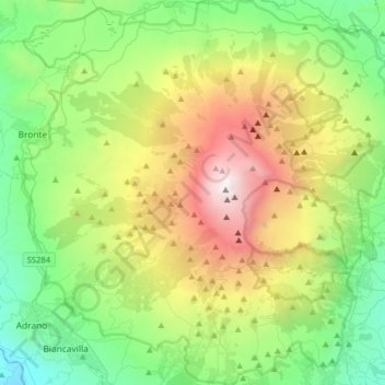
Name: Mount Etna topographic map, elevation, terrain.
Location: Mount Etna, Catania, Sicily, Italy (37.62235 14.82551 37.87524 15.13241)
Average elevation: 1,157 m
Minimum elevation: 144 m
Maximum elevation: 3,312 m
Make a donation
Gear up for your next adventure:
As an Amazon Associate, this site earns from qualifying purchases at no extra cost to you.
Other topographic maps
Click on a map to view its topography, its elevation and its terrain.