Geolocate

Barza topographic map

Click on the map to display elevation.

About this map

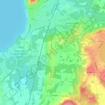
Name: Barza topographic map, elevation, terrain.

Location: Barza, Ispra, Varese, Lombardy, 21027, Italy (45.77852 8.60172 45.81852 8.64172)

Average elevation: 226 m

Minimum elevation: 191 m

Maximum elevation: 301 m

Other topographic maps

Click on a map to view its topography, its elevation and its terrain.

Laveno-Mombello

Italy > Lombardy > Varese

Average elevation: 290 m

Castellanza

Italy > Lombardy > Varese

Average elevation: 221 m

Gear up for your next adventure:

🧢Beanie Hat - Keep your head warm in cold weather
🧢Outdoor Visor - Breathable visor for sunny hikes
🧤Thermal Hiking Gloves - Grip-enhanced gloves for cold-weather altitude trekking
🧦Outdoor Socks - Durable socks designed for hiking and outdoor sports
Lightweight Backpacking Tent - Compact tent for efficient hiking trips

As an Amazon Associate, this site earns from qualifying purchases at no extra cost to you.