Geolocate

Li Rochette topographic map

Click on the map to display elevation.

About this map

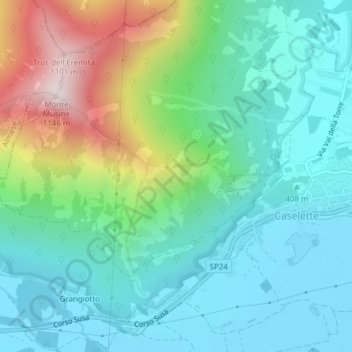
Name: Li Rochette topographic map, elevation, terrain.

Location: Li Rochette, Caselette, Torino, Piedmont, Italy (45.09774 7.45769 45.11774 7.47769)

Average elevation: 530 m

Minimum elevation: 322 m

Maximum elevation: 1,112 m

Gear up for your next adventure:

🛶Kayak Accessories - Essential gear for safe and fun kayaking adventures
🥾Hiking Shorts - Breathable shorts suitable for summer hikes
💧Filtered Water Bottle - Safe drinking water on the go
🎒Backpack Rain Cover - External shield to keep your entire pack dry
🥾Lightweight Hiking Shoes - Comfortable shoes for day hikes

As an Amazon Associate, this site earns from qualifying purchases at no extra cost to you.