
Make a donation
Gear up for your next adventure:
As an Amazon Associate, this site earns from qualifying purchases at no extra cost to you.
Alberta topographic map
Click on the map to display elevation.
Make a donation
Gear up for your next adventure:
As an Amazon Associate, this site earns from qualifying purchases at no extra cost to you.
About this map
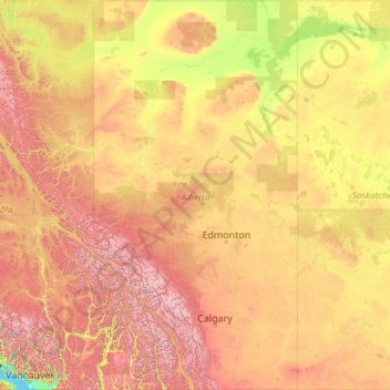
Name: Alberta topographic map, elevation, terrain.
Location: Alberta, Canada (48.99667 -120.00138 60.00047 -110.00476)
Average elevation: 806 m
Minimum elevation: 0 m
Maximum elevation: 3,512 m
Canada trails, hiking, mountain biking, running and outdoor activities
Make a donation
Gear up for your next adventure:
As an Amazon Associate, this site earns from qualifying purchases at no extra cost to you.
Other topographic maps
Click on a map to view its topography, its elevation and its terrain.
Toronto
Despite its deep ravines, Toronto is not remarkably hilly, but its elevation does increase steadily away from the lake. Elevation differences range from 76.5 metres (251 ft) above sea level at the Lake Ontario shore to 209 m (686 ft) ASL near the York University grounds in the city's north end at the…
Average elevation: 113 m
Banff
Canada > Alberta > Banff > Banff
Banff is a town within Banff National Park in Alberta, Canada. It is located in Alberta's Rockies along the Trans-Canada Highway, approximately 126 km (78 mi) west of Calgary and 58 km (36 mi) east of Lake Louise. At 1,400 to 1,630 m (4,590 to 5,350 ft) above sea level, Banff is the community with the second…
Average elevation: 1,615 m
Peterborough
Canada > Ontario > Peterborough
Peterborough's topography is largely defined by land formations created by the receding Wisconsian glaciers 10,000–15,000 years ago. The South End and Downtown portions of the City sit on what was the bottom of the glacial Lake Peterborough—part of a glacial spillway created when glacial meltwaters from…
Average elevation: 235 m
Make a donation
Gear up for your next adventure:
As an Amazon Associate, this site earns from qualifying purchases at no extra cost to you.
London
Canada > Ontario > London > London
London has a humid continental climate (Köppen Dfb), though due to its downwind location relative to Lake Huron and elevation changes across the city, it is virtually on the Dfa/Dfb (hot summer) boundary favouring the former climate zone to the southwest of the confluence of the South and North Thames Rivers,…
Average elevation: 268 m
Guelph
This region of Ontario has cold winters and warm, humid summers, falling into the Köppen climate classification Dfb zone, with moderately high rainfall and snowfall. It is generally a couple of degrees cooler than lower elevation regions on the Great Lakes shorelines, especially so in winter, the exception…
Average elevation: 344 m
Make a donation
Gear up for your next adventure:
As an Amazon Associate, this site earns from qualifying purchases at no extra cost to you.
Make a donation
Gear up for your next adventure:
As an Amazon Associate, this site earns from qualifying purchases at no extra cost to you.
Make a donation
Gear up for your next adventure:
As an Amazon Associate, this site earns from qualifying purchases at no extra cost to you.
Keswick
Canada > Ontario > York Region
Keswick's geographical coordinates are 44.22°N, 79.45°W, and its elevation above sea level is 221m/762 ft. It has a geographical area of 16.25 km² according to Statistics Canada. It is bound on the north by Roches Point, the east by Woodbine Avenue, the south by East Gwillimbury (Ravenshoe Road) and the…
Average elevation: 228 m
Make a donation
Gear up for your next adventure:
As an Amazon Associate, this site earns from qualifying purchases at no extra cost to you.
Mount Farnham
Canada > British Columbia > Regional District of East Kootenay > Area G (Forster Creek/Mount Assiniboine)
Average elevation: 2,791 m
Make a donation
Gear up for your next adventure:
As an Amazon Associate, this site earns from qualifying purchases at no extra cost to you.
Hope
Canada > British Columbia > Fraser Valley Regional District > Hope > Hope
Average elevation: 435 m
Thompson River
Canada > British Columbia > Thompson-Nicola Regional District
Average elevation: 1,127 m
Tomlinson Lake
Canada > Ontario > Thunder Bay District > Unorganized Thunder Bay District
Average elevation: 489 m
Make a donation
Gear up for your next adventure:
As an Amazon Associate, this site earns from qualifying purchases at no extra cost to you.
Lake Louise
Canada > Alberta > Improvement District No. 9
Lake Louise is a hamlet within Banff National Park in Alberta, Canada. Named after Princess Louise, Duchess of Argyll, it lies in Alberta's Rockies on the Bow River, 3 km (1.9 mi) northeast of the lake that shares its name. Initially settled in 1884 as an outpost for the Canadian Pacific Railway, Lake Louise…
Average elevation: 1,617 m
Make a donation
Gear up for your next adventure:
As an Amazon Associate, this site earns from qualifying purchases at no extra cost to you.
Make a donation
Gear up for your next adventure:
As an Amazon Associate, this site earns from qualifying purchases at no extra cost to you.
Burnaby
Canada > British Columbia > Metro Vancouver Regional District > Burnaby
Burnaby occupies 98.60 square kilometres (38.07 sq mi) and is located at the geographic centre of the Metro Vancouver area and home to the Metro Vancouver regional government in Metrotown. Situated between the city of Vancouver on the west and Port Moody, Coquitlam, and New Westminster on the east, Burnaby is…
Average elevation: 144 m
Make a donation
Gear up for your next adventure:
As an Amazon Associate, this site earns from qualifying purchases at no extra cost to you.
Make a donation
Gear up for your next adventure:
As an Amazon Associate, this site earns from qualifying purchases at no extra cost to you.
Blue Earth Lake
Canada > British Columbia > Thompson-Nicola Regional District > Area I (Blue Sky Country)
Average elevation: 1,525 m
Make a donation
Gear up for your next adventure:
As an Amazon Associate, this site earns from qualifying purchases at no extra cost to you.
Laurentian Mountains
One of Quebec's official regions is called Laurentides. The mountain range runs through four other regions; Capitale-Nationale, Outaouais, Lanaudière, and Mauricie. The elevation generally ranges from around 500 m (1,640 ft) to 1,000 m (3,280 ft) with Mont Raoul-Blanchard being its highest peak, at 1,166 m…
Average elevation: 348 m
Kamloops
Canada > British Columbia > Thompson-Nicola Regional District > Kamloops
Average elevation: 875 m
Make a donation
Gear up for your next adventure:
As an Amazon Associate, this site earns from qualifying purchases at no extra cost to you.
Make a donation
Gear up for your next adventure:
As an Amazon Associate, this site earns from qualifying purchases at no extra cost to you.
Grouse Mountain
Canada > British Columbia > Metro Vancouver Regional District
Grouse Mountain is one of the North Shore Mountains of the Pacific Ranges in the District Municipality of North Vancouver, British Columbia, Canada. With a maximum elevation of over 1,200 m (4,100 feet) at its peak, the mountain is the site of an alpine ski area, Grouse Mountain Resort, which overlooks Greater…
Average elevation: 968 m
Riding Mountain National Park
The climate in the Riding Mountain region is similar to that of other regions of southwestern Manitoba. Under the Köppen classification it has a continental climate. It includes grasslands, upland boreal and eastern deciduous forest ecosystems. The park has hot summers and cold winters, with annual rainfall…
Average elevation: 488 m
Make a donation
Gear up for your next adventure:
As an Amazon Associate, this site earns from qualifying purchases at no extra cost to you.
Gillies Bay
Canada > British Columbia > qathet Regional District > Area D (Texada Island)
Average elevation: 53 m
Make a donation
Gear up for your next adventure:
As an Amazon Associate, this site earns from qualifying purchases at no extra cost to you.
Mount Rundle
Canada > Alberta > Improvement District No. 9
In Banff, the Spray River trailhead for the first peak taking the Mount Rundle Trail, is near the Spray River bridge on the road to the Banff Springs Golf Course. The all-day hike (from 8–10 hours) from the trailhead to the peak is about 5 kilometres (3.1 mi) one-way and has an elevation gain of about 993…
Average elevation: 2,353 m
Make a donation
Gear up for your next adventure:
As an Amazon Associate, this site earns from qualifying purchases at no extra cost to you.
Northbrook
Canada > Ontario > Lennox and Addington County > Addington Highlands
Average elevation: 260 m
Make a donation
Gear up for your next adventure:
As an Amazon Associate, this site earns from qualifying purchases at no extra cost to you.
Fraser River Park
Canada > British Columbia > Metro Vancouver Regional District > Vancouver
Average elevation: 19 m
Kenyon Lake
Canada > British Columbia > Area F (McConnell Creek/Hatzic Prairie)
Average elevation: 765 m
Morrissey Provincial Park
Canada > British Columbia > Regional District of East Kootenay > Area A (Upper Flathead/Elk Valley)
Average elevation: 1,040 m
Make a donation
Gear up for your next adventure:
As an Amazon Associate, this site earns from qualifying purchases at no extra cost to you.
Celista
Canada > British Columbia > Columbia-Shuswap Regional District > Area F (Scotch Creek/Seymour Arm)
Average elevation: 407 m
Make a donation
Gear up for your next adventure:
As an Amazon Associate, this site earns from qualifying purchases at no extra cost to you.
Murdock River
Canada > Ontario > Sudbury District > Unorganized North Sudbury
Average elevation: 224 m
Winnipeg
Canada > Manitoba > Winnipeg > Winnipeg
Winnipeg lies at the bottom of the Red River Valley, a flood plain with an extremely flat topography. It is on the eastern edge of the Canadian Prairies in Western Canada and is known as the "Gateway to the West". Winnipeg is bordered by tallgrass prairie to the west and south and the aspen parkland to the…
Average elevation: 236 m
Make a donation
Gear up for your next adventure:
As an Amazon Associate, this site earns from qualifying purchases at no extra cost to you.
Make a donation
Gear up for your next adventure:
As an Amazon Associate, this site earns from qualifying purchases at no extra cost to you.
Make a donation
Gear up for your next adventure:
As an Amazon Associate, this site earns from qualifying purchases at no extra cost to you.
Mission Creek Regional Park
Canada > British Columbia > Regional District of Central Okanagan > Kelowna
Average elevation: 436 m
Make a donation
Gear up for your next adventure:
As an Amazon Associate, this site earns from qualifying purchases at no extra cost to you.
Make a donation
Gear up for your next adventure:
As an Amazon Associate, this site earns from qualifying purchases at no extra cost to you.