
Make a donation
Gear up for your next adventure:
As an Amazon Associate, this site earns from qualifying purchases at no extra cost to you.
Kenyon Lake topographic map
Click on the map to display elevation.
Make a donation
Gear up for your next adventure:
As an Amazon Associate, this site earns from qualifying purchases at no extra cost to you.
About this map
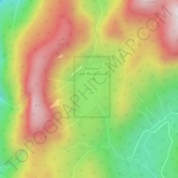
Name: Kenyon Lake topographic map, elevation, terrain.
Average elevation: 765 m
Minimum elevation: 308 m
Maximum elevation: 1,209 m
British Columbia trails, hiking, mountain biking, running and outdoor activities
Make a donation
Gear up for your next adventure:
As an Amazon Associate, this site earns from qualifying purchases at no extra cost to you.
Other topographic maps
Click on a map to view its topography, its elevation and its terrain.
Stave Lake
Canada > British Columbia > Area F (McConnell Creek/Hatzic Prairie)
Average elevation: 576 m
Golden Ears Park
Canada > British Columbia > Area F (McConnell Creek/Hatzic Prairie)
Average elevation: 1,292 m