
Make a donation
Gear up for your next adventure:
As an Amazon Associate, this site earns from qualifying purchases at no extra cost to you.
Thistle Lake topographic map
Click on the map to display elevation.
Make a donation
Gear up for your next adventure:
As an Amazon Associate, this site earns from qualifying purchases at no extra cost to you.
About this map
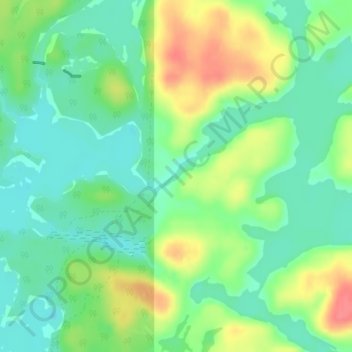
Name: Thistle Lake topographic map, elevation, terrain.
Average elevation: 288 m
Minimum elevation: 264 m
Maximum elevation: 330 m
Nipissing District trails, hiking, mountain biking, running and outdoor activities
Make a donation
Gear up for your next adventure:
As an Amazon Associate, this site earns from qualifying purchases at no extra cost to you.
Other topographic maps
Click on a map to view its topography, its elevation and its terrain.
North Bay
Canada > Ontario > Nipissing District
The climate in North Bay is common to most places in Northern Ontario. North Bay tends to be a less humid climate than that found in Southern Ontario due somewhat to the distance from the Great Lakes and less warm than some other locations in Northern Ontario due to cooling from Lake Nipissing. On May 31,…
Average elevation: 266 m
Make a donation
Gear up for your next adventure:
As an Amazon Associate, this site earns from qualifying purchases at no extra cost to you.
Lake Nipissing
Canada > Ontario > Nipissing District
Lake Nipissing (/ˈnɪpəsɪŋ/; French: lac Nipissing, Ojibwe: Gichi-nibiinsing-zaaga’igan) is a lake in the Canadian province of Ontario. It has a surface area of 873.3 km2 (337.2 sq mi), a mean elevation of 196 m (643 ft) above sea level, and is located between the Ottawa River and Georgian Bay. Lake…
Average elevation: 272 m
Make a donation
Gear up for your next adventure:
As an Amazon Associate, this site earns from qualifying purchases at no extra cost to you.
Kawawaymog Lake
Canada > Ontario > Nipissing District > Unorganized South Nipissing
Average elevation: 385 m
Make a donation
Gear up for your next adventure:
As an Amazon Associate, this site earns from qualifying purchases at no extra cost to you.
Guthrie Lake
Canada > Ontario > Nipissing District > Unorganized South Nipissing
Average elevation: 299 m
Rowan Lake
Canada > Ontario > Nipissing District > Unorganized South Nipissing
Average elevation: 281 m
Make a donation
Gear up for your next adventure:
As an Amazon Associate, this site earns from qualifying purchases at no extra cost to you.
Temagami
Canada > Ontario > Nipissing District
Temagami provides rugged topography, which is excellent for canoeing and hiking. There are numerous viewpoints in the municipality, including High Rock and Caribou Mountain, which contains a 100 ft (30 m) fire tower on its summit.
Average elevation: 319 m
Make a donation
Gear up for your next adventure:
As an Amazon Associate, this site earns from qualifying purchases at no extra cost to you.
Madawaska Highlands
Canada > Ontario > Nipissing District > Unorganized South Nipissing
Average elevation: 371 m
Make a donation
Gear up for your next adventure:
As an Amazon Associate, this site earns from qualifying purchases at no extra cost to you.
Crotch Lake
Canada > Ontario > Nipissing District > Unorganized South Nipissing
Average elevation: 414 m
Make a donation
Gear up for your next adventure:
As an Amazon Associate, this site earns from qualifying purchases at no extra cost to you.
Ralph Bice Lake
Canada > Ontario > Nipissing District > Unorganized South Nipissing
Average elevation: 464 m
Victoria Lake
Canada > Ontario > Nipissing District > South Algonquin Township
Average elevation: 407 m
Make a donation
Gear up for your next adventure:
As an Amazon Associate, this site earns from qualifying purchases at no extra cost to you.
Wenona Lake
Canada > Ontario > Nipissing District > Unorganized South Nipissing
Average elevation: 467 m
Make a donation
Gear up for your next adventure:
As an Amazon Associate, this site earns from qualifying purchases at no extra cost to you.
Papineau Lake
Canada > Ontario > Nipissing District > Papineau-Cameron Township
Average elevation: 334 m
Cedar Lake
Canada > Ontario > Nipissing District > Unorganized South Nipissing
Average elevation: 370 m
Make a donation
Gear up for your next adventure:
As an Amazon Associate, this site earns from qualifying purchases at no extra cost to you.
Bellwood
Canada > Ontario > Nipissing District > South Algonquin Township > Whitney
Average elevation: 410 m
Make a donation
Gear up for your next adventure:
As an Amazon Associate, this site earns from qualifying purchases at no extra cost to you.
Moccasin Lake
Canada > Ontario > Nipissing District > Unorganized South Nipissing
Average elevation: 465 m
Sunday Lake
Canada > Ontario > Nipissing District > Unorganized South Nipissing
Average elevation: 464 m
Make a donation
Gear up for your next adventure:
As an Amazon Associate, this site earns from qualifying purchases at no extra cost to you.
Bissett Lake
Canada > Ontario > Nipissing District > Unorganized South Nipissing
Average elevation: 367 m
Make a donation
Gear up for your next adventure:
As an Amazon Associate, this site earns from qualifying purchases at no extra cost to you.
Rutherglen
Canada > Ontario > Nipissing District > Bonfield Township > Rutherglen
Average elevation: 236 m
Biggar Lake
Canada > Ontario > Nipissing District > Unorganized South Nipissing
Average elevation: 409 m
Make a donation
Gear up for your next adventure:
As an Amazon Associate, this site earns from qualifying purchases at no extra cost to you.
Madawaska Highlands
Canada > Ontario > Nipissing District > South Algonquin Township
Average elevation: 442 m
Make a donation
Gear up for your next adventure:
As an Amazon Associate, this site earns from qualifying purchases at no extra cost to you.
Make a donation
Gear up for your next adventure:
As an Amazon Associate, this site earns from qualifying purchases at no extra cost to you.
Temagami
Canada > Ontario > Nipissing District
Temagami provides rugged topography, which is excellent for canoeing and hiking. There are numerous viewpoints in the municipality, including High Rock and Caribou Mountain, which contains a 100 ft (30 m) fire tower on its summit.
Average elevation: 319 m
Cedar Lake
Canada > Ontario > Nipissing District > Unorganized South Nipissing
Average elevation: 370 m
Make a donation
Gear up for your next adventure:
As an Amazon Associate, this site earns from qualifying purchases at no extra cost to you.
North Bay
Canada > Ontario > Nipissing District
The climate in North Bay is common to most places in Northern Ontario. North Bay tends to be a less humid climate than that found in Southern Ontario due somewhat to the distance from the Great Lakes and less warm than some other locations in Northern Ontario due to cooling from Lake Nipissing. On May 31,…
Average elevation: 266 m
Maple Leaf Lake
Canada > Ontario > Nipissing District > Unorganized South Nipissing
Average elevation: 510 m
Make a donation
Gear up for your next adventure:
As an Amazon Associate, this site earns from qualifying purchases at no extra cost to you.
Make a donation
Gear up for your next adventure:
As an Amazon Associate, this site earns from qualifying purchases at no extra cost to you.
Radiant Lake
Canada > Ontario > Nipissing District > Unorganized South Nipissing
Average elevation: 295 m
Bridle Lake
Canada > Ontario > Nipissing District > Unorganized South Nipissing
Average elevation: 430 m
Make a donation
Gear up for your next adventure:
As an Amazon Associate, this site earns from qualifying purchases at no extra cost to you.
Sheriff Pond
Canada > Ontario > Nipissing District > Unorganized South Nipissing
Average elevation: 456 m
Temagami
Canada > Ontario > Nipissing District
Temagami provides rugged topography, which is excellent for canoeing and hiking. There are numerous viewpoints in the municipality, including High Rock and Caribou Mountain, which contains a 100 ft (30 m) fire tower on its summit.
Average elevation: 319 m
Make a donation
Gear up for your next adventure:
As an Amazon Associate, this site earns from qualifying purchases at no extra cost to you.
North Bay
Canada > Ontario > Nipissing District
The climate in North Bay is common to most places in Northern Ontario. North Bay tends to be a less humid climate than that found in Southern Ontario due somewhat to the distance from the Great Lakes and less warm than some other locations in Northern Ontario due to cooling from Lake Nipissing. On May 31,…
Average elevation: 266 m