
Democratic Republic of the Congo topographic map
Interactive map
Click on the map to display elevation.
Democratic Republic of the Congo
The tropical climate produced the Congo River system which dominates the region topographically along with the rainforest it flows through. The Congo Basin occupies nearly the entire country and an area of nearly 1,000,000 km2 (390,000 sq mi). The river and its tributaries form the backbone of Congolese economics and transportation. Major tributaries include the Kasai, Sangha, Ubangi, Ruzizi, Aruwimi, and Lulonga.
About this map
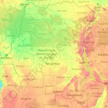
Name: Democratic Republic of the Congo topographic map, elevation, terrain.
Location: Democratic Republic of the Congo (-13.45904 12.03907 5.39200 31.30568)
Average elevation: 839 m
Minimum elevation: 215 m
Maximum elevation: 4,273 m
Other topographic maps
Click on a map to view its topography, its elevation and its terrain.
Vancouver
Canada > British Columbia > Metro Vancouver Regional District
Winters in Greater Vancouver are the fourth-mildest of Canadian cities after nearby Victoria, Nanaimo and Duncan, all on Vancouver Island. Vancouver's growing season averages 237 days, from March 18 until November 10. Vancouver's 1981–2010 USDA Plant Hardiness Zone ranges from 8A to 9A depending on elevation…
Average elevation: 34 m
Ontario
Despite the absence of any mountainous terrain in the province, there are large areas of uplands, particularly within the Canadian Shield which traverses the province from northwest to southeast and also above the Niagara Escarpment which crosses the south. The highest point is Ishpatina Ridge at 693 metres…
Average elevation: 245 m
Pinellas County
Elevation in the county ranges from mean sea level to its highest natural point of 110 feet (34 m) near the intersection of SR 580 and Countryside Blvd. in Clearwater. Due to its small size and high population, by the early 21st century Pinellas County has been mostly built out, with very little developable…
Average elevation: 4 m
Toronto
Despite its deep ravines, Toronto is not remarkably hilly, but its elevation does increase steadily away from the lake. Elevation differences range from 76.5 metres (251 ft) above sea level at the Lake Ontario shore to 209 m (686 ft) ASL near the York University grounds in the city's north end at the…
Average elevation: 113 m
Calgary
Calgary experiences a semi-monsoonal humid continental climate (Köppen climate classification Dwb) within eastern parts of the city and a subarctic climate (Köppen climate classification Dwc) within western parts of the city due to an increase in elevation. The city has warm, comfortable summers and…
Average elevation: 1,106 m
British Columbia
The Southern Interior cities of Kamloops and Penticton have some of the warmest and longest summer climates in Canada (while higher elevations are cold and snowy), although their temperatures are often exceeded north of the Fraser Canyon, close to the confluence of the Fraser and Thompson rivers, where the…
Average elevation: 708 m
Canada
Average elevation: 254 m
Quebec
Quebec's topography is very different from one region to another due to the varying composition of the ground, the climate, and the proximity to water. More than 95% of Quebec's territory, including the Labrador Peninsula, lies within the Canadian Shield. It is generally a quite flat and exposed mountainous…
Average elevation: 195 m
Vancouver Island
The rain shadow effect of the island's mountains, as well as the mountains of Washington's Olympic Peninsula, creates wide variation in precipitation. The west coast is considerably wetter than the east coast. Average annual precipitation ranges from 6,650 mm (262 in) at Hucuktlis Lake on the west coast…
Average elevation: 411 m
Peterborough
Canada > Ontario > Peterborough
Peterborough's topography is largely defined by land formations created by the receding Wisconsian glaciers 10,000–15,000 years ago. The South End and Downtown portions of the City sit on what was the bottom of the glacial Lake Peterborough—part of a glacial spillway created when glacial meltwaters from…
Average elevation: 235 m
Pasco County
A portion of Eastern Pasco County contains rolling topography with elevations from 100 to 160 ft (30 to 49 m), along with San Antonio and St. Leo.
Average elevation: 18 m
Edmonton
Edmonton is on the North Saskatchewan River, at an elevation of 671 m (2,201 ft). It is North America's northernmost city with a metropolitan population over one million. It is at the same latitude as Hamburg (Germany); Dublin (Ireland); Manchester (United Kingdom); and Magnitogorsk (Russia). It is south of…
Average elevation: 690 m
Colorado Springs
United States > Colorado > El Paso County
At 6,035 feet (1,839 m) the city stands over 1 mile (1.6 km) above sea level. Colorado Springs is near the base of Pikes Peak, which rises 14,115 feet (4,302.31 m) above sea level on the eastern edge of the Southern Rocky Mountains. The city is the largest city north of Mexico above 6000 feet in elevation.
Average elevation: 2,252 m
Maryland
Sixteen of Maryland's twenty-three counties, as well as the city of Baltimore, border the tidal waters of the Chesapeake Bay estuary and its many tributaries, which combined total more than 4,000 miles of shoreline. Although one of the smallest states in the U.S., it features a variety of climates and…
Average elevation: 149 m
Burnaby
Canada > British Columbia > Metro Vancouver Regional District
Burnaby occupies 98.6 square kilometres (38.1 sq mi) and is located at the geographic centre of the Metro Vancouver Regional District. The regional district's government is located in Burnaby's Metrotown area. Situated between the city of Vancouver on the west and Port Moody, Coquitlam, and New Westminster on…
Average elevation: 59 m
Halifax
The coastline is heavily indented, accounting for its length of approximately 400 km (250 mi), with the northern boundary of the municipality usually being between 50–60 km (31–37 mi) inland. The coast is mostly rock with small isolated sand beaches in sheltered bays. The largest coastal features include…
Average elevation: 46 m
Coquitlam
Canada > British Columbia > Metro Vancouver Regional District
Like much of Metro Vancouver, Coquitlam has an oceanic climate (Köppen climate type Cfb), experiencing mild temperatures and high precipitation; warm, dry summers and cool, wet winters. However, compared to most other cities in the area, precipitation is especially heavy in Coquitlam due to its proximity to…
Average elevation: 190 m
Scarborough
Topographically, Scarborough is dominated by two watersheds, Highland Creek and the Rouge River. Highland Creek lies almost entirely within Scarborough and occupies approximately 70% of its total area. It occupies the western half of Scarborough, while the Rouge River flows through the eastern portion. Both of…
Average elevation: 138 m
Saltspring Island
Canada > British Columbia > Capital Regional District > Salt Spring Island Electoral Area
Average elevation: 72 m
Township of Langley
Canada > British Columbia > Metro Vancouver Regional District
Average elevation: 47 m
Winnipeg
Winnipeg lies at the bottom of the Red River Valley, a flood plain with an extremely flat topography. It is on the eastern edge of the Canadian Prairies in Western Canada and is known as the "Gateway to the West". Winnipeg is bordered by tallgrass prairie to the west and south and the aspen parkland to the…
Average elevation: 236 m
Saskatoon
Saskatoon lies on a long belt of rich, potassic chernozem in middle-southern Saskatchewan and is found in the aspen parkland biome. The lack of surrounding mountainous topography gives the city a relatively flat grid, though the city does sprawl over a few hills and into a few valleys. The lowest point in the…
Average elevation: 504 m
Guelph
This region of Ontario has cold winters and warm, humid summers, falling into the Köppen climate classification Dfb zone, with moderately high rainfall and snowfall. It is generally a couple of degrees cooler than lower elevation regions on the Great Lakes shorelines, especially so in winter, the exception…
Average elevation: 344 m
Newfoundland and Labrador
In 1496, John Cabot obtained a charter from English King Henry VII to "sail to all parts, countries and seas of the East, the West and of the North, under our banner and ensign and to set up our banner on any new-found-land" and on June 24, 1497, landed in Cape Bonavista. Historians disagree on whether Cabot…
Average elevation: 192 m
Kamloops
Canada > British Columbia > Thompson-Nicola Regional District > Kamloops
Average elevation: 875 m
Phoenix
United States > Arizona > Maricopa County
Phoenix is in the southwestern United States, in the south-central portion of Arizona; about halfway between Tucson to the southeast and Flagstaff to the north. By car, the city is approximately 150 miles (240 kilometers) north of the US-Mexico border at Sonoyta and 180 mi (290 km) north of the border at…
Average elevation: 481 m