
Golden topographic map
Click on the map to display elevation.
About this map
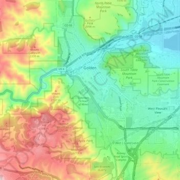
Name: Golden topographic map, elevation, terrain.
Location: Golden, Jefferson County, Colorado, United States (39.70065 -105.24196 39.78711 -105.16186)
Average elevation: 1,936 m
Minimum elevation: 1,673 m
Maximum elevation: 2,410 m
Other topographic maps
Click on a map to view its topography, its elevation and its terrain.
Evergreen
United States > Colorado > Jefferson County
Evergreen sits at an elevation of 7,220 feet (2,200 m) in the Rocky Mountains, 19 miles west of Denver, Colorado. Its addresses are oriented according to the Street_system_of_Denver.
Average elevation: 2,309 m
Lakewood
United States > Colorado > Jefferson County > Lakewood
Lakewood is located at 39°42′17″N 105°04′53″W / 39.70472°N 105.08139°W / 39.70472; -105.08139 at an elevation of 5,518 feet (1,682 m). Located at the junction of U.S. Route 6 and Colorado State Highway 121 in central Colorado, the city lies immediately west of Denver and 62 miles (100 km)…
Average elevation: 1,717 m
Doublehead Mountain
United States > Colorado > Jefferson County > Aspen Park
Average elevation: 2,468 m
Evergreen
United States > Colorado > Jefferson County
Evergreen sits at an elevation of 7,220 feet (2,200 m) in the Rocky Mountains, 19 miles west of Denver, Colorado.
Average elevation: 2,301 m
Conifer
United States > Colorado > Jefferson County
Conifer is located in Jefferson County at coordinates 39°31′16″N 105°18′19″W / 39.5211°N 105.3053°W / 39.5211; -105.3053 (Conifer, Colorado) and elevation 8,262 feet (2,518 m).
Average elevation: 2,573 m
Evergreen
United States > Colorado > Jefferson County
Evergreen sits at an elevation of 7,220 feet (2,200 m) in the Rocky Mountains, 19 miles west of Denver, Colorado.
Average elevation: 2,309 m
Indiana Street Open Space
United States > Colorado > Jefferson County > Arvada
Average elevation: 1,699 m
Evergreen
United States > Colorado > Jefferson County
Evergreen sits at an elevation of 7,220 feet (2,200 m) in the Rocky Mountains, 19 miles west of Denver, Colorado.
Average elevation: 2,309 m
Denver Mountain Park Site
United States > Colorado > Jefferson County > Aspen Park
Average elevation: 2,516 m