
Dubuque County topographic map
Interactive map
Click on the map to display elevation.
About this map
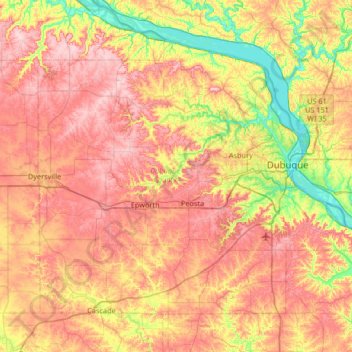
Name: Dubuque County topographic map, elevation, terrain.
Location: Dubuque County, Iowa, United States (42.29334 -91.13344 42.67462 -90.47332)
Average elevation: 284 m
Minimum elevation: 180 m
Maximum elevation: 381 m
The county seat is Dubuque, Iowa, which is located along the Mississippi River in the east-central portion of the county. Eastern Dubuque County is markedly different from the western portion in that its topography is very uneven. The city of Dubuque and surrounding areas adjacent to the Mississippi River have many steep hills, bluffs, and ravines. Also, the eastern portion is more heavily wooded than the west, which is mostly rolling farmland.
Other topographic maps
Click on a map to view its topography, its elevation and its terrain.
Kiron
United States > Iowa > Crawford County
Kiron, Crawford County, Iowa, United States
Average elevation: 412 m
Sioux City
United States > Iowa > Woodbury County
Sioux City, Woodbury County, Iowa, United States
Average elevation: 352 m
LaMotte Recreational Park
United States > Iowa > Jackson County > La Motte
LaMotte Recreational Park, La Motte, Jackson County, Iowa, United States
Average elevation: 295 m
Alta Vista
United States > Iowa > Chickasaw County
Alta Vista, Chickasaw County, Iowa, United States
Average elevation: 360 m
Moravia
United States > Iowa > Appanoose County
Moravia, Appanoose County, Iowa, United States
Average elevation: 300 m
Maxwell
United States > Iowa > Story County
Maxwell, Story County, Iowa, United States
Average elevation: 274 m
Redfield
United States > Iowa > Dallas County
Redfield, Dallas County, Iowa, United States
Average elevation: 298 m
Gowrie
United States > Iowa > Webster County
Gowrie, Webster County, Iowa, United States
Average elevation: 347 m
Adel
United States > Iowa > Dallas County
Adel, Dallas County, Iowa, United States
Average elevation: 292 m
Cairo
United States > Iowa > Louisa County
Cairo, Louisa County, Iowa, United States
Average elevation: 212 m
Catfish Creek
United States > Iowa > Dubuque County > Dubuque
Catfish Creek, Dubuque, Dubuque County, Iowa, United States
Average elevation: 257 m
Rose Hill
United States > Iowa > Mahaska County
Rose Hill, Mahaska County, Iowa, United States
Average elevation: 238 m
Cushing
United States > Iowa > Woodbury County
Cushing, Woodbury County, Iowa, United States
Average elevation: 402 m
Johnson County
United States > Iowa > Johnson County
Johnson County, Iowa, United States
Average elevation: 226 m
Dyersville
United States > Iowa > Dubuque County
Dyersville, Dubuque County, Iowa, 52040, United States
Average elevation: 307 m
Hillsboro
United States > Iowa > Henry County
Hillsboro, Henry County, Iowa, United States
Average elevation: 219 m
Loveland
United States > Iowa > Pottawattamie County
Loveland, Pottawattamie County, Iowa, United States
Average elevation: 330 m
Dysart
United States > Iowa > Tama County
Dysart, Tama County, Iowa, United States
Average elevation: 293 m
Centerville
United States > Iowa > Appanoose County
Centerville, Appanoose County, Iowa, 52544, United States
Average elevation: 293 m
Hanson Lake
United States > Iowa > Black Hawk County > Evansdale
Hanson Lake, Evansdale, Black Hawk County, Iowa, United States
Average elevation: 258 m
Blanchard
United States > Iowa > Page County
Blanchard, Page County, Iowa, United States
Average elevation: 305 m
Waukee
United States > Iowa > Dallas County
Waukee, Dallas County, Iowa, 50263, United States
Average elevation: 298 m
Westgate
United States > Iowa > Fayette County
Westgate, Fayette County, Iowa, United States
Average elevation: 333 m
Holy Cross
United States > Iowa > Dubuque County
Holy Cross, Dubuque County, Iowa, United States
Average elevation: 355 m
Charles City
United States > Iowa > Floyd County
Charles City, Floyd County, Iowa, 50616, United States
Average elevation: 315 m
Panorama Park
United States > Iowa > Scott County > Pleasant Valley Township
Panorama Park, Pleasant Valley Township, Scott County, Iowa, United States
Average elevation: 190 m
Ridgeway
United States > Iowa > Winneshiek County
Ridgeway, Winneshiek County, Iowa, United States
Average elevation: 364 m
Davenport
United States > Iowa > Scott County
Davenport, Scott County, Iowa, United States
Average elevation: 205 m
Berkley
United States > Iowa > Boone County
Berkley, Boone County, Iowa, United States
Average elevation: 301 m
Grand River
United States > Iowa > Decatur County
Grand River, Decatur County, Iowa, United States
Average elevation: 313 m
Stephenson Park
United States > Iowa > Henry County > Lowell
Stephenson Park, Lowell, Henry County, Iowa, United States
Average elevation: 189 m
Hills
United States > Iowa > Johnson County
Hills, Johnson County, Iowa, 52235, United States
Average elevation: 196 m
St. Olaf
United States > Iowa > Clayton County
St. Olaf, Clayton County, Iowa, United States
Average elevation: 282 m
Calmar
United States > Iowa > Winneshiek County
Calmar, Winneshiek County, Iowa, United States
Average elevation: 376 m
Riverton
United States > Iowa > Fremont County
Riverton, Fremont County, Iowa, United States
Average elevation: 292 m
Pioneer
United States > Iowa > Humboldt County
Pioneer, Humboldt County, Iowa, United States
Average elevation: 361 m
Unionville
United States > Iowa > Appanoose County > Unionville
Unionville, Appanoose County, Iowa, United States
Average elevation: 284 m
Norwalk
United States > Iowa > Warren County
Norwalk, Warren County, Iowa, 50211, United States
Average elevation: 271 m
Denver
United States > Iowa > Bremer County
Denver, Bremer County, Iowa, 50622, United States
Average elevation: 298 m
Hills
United States > Iowa > Johnson County > Hills > Hills
Hills, Johnson County, Iowa, 52235, United States
Average elevation: 196 m