Geolocate

Holy Cross topographic map

Click on the map to display elevation.

About this map

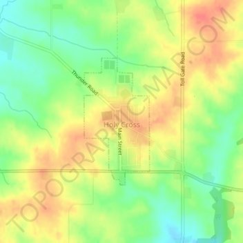
Name: Holy Cross topographic map, elevation, terrain.

Location: Holy Cross, Dubuque County, Iowa, United States (42.59381 -91.00139 42.60792 -90.99149)

Average elevation: 355 m

Minimum elevation: 327 m

Maximum elevation: 380 m

Gear up for your next adventure:

💡LED Camping Lantern - Illuminate your campsite with long-lasting lanterns
🥾Trail Hiking Shoes - Durable shoes designed for rugged trails
🔥Emergency Fire Starter - Reliable ignition source for all weather conditions
Camping Tent - Weather-resistant tents suitable for 2 to 6 people
🦯Trekking Poles - Reduced impact on joints for steep topographic climbs

As an Amazon Associate, this site earns from qualifying purchases at no extra cost to you.