
Van Buren County topographic map
Interactive map
Click on the map to display elevation.
About this map
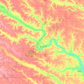
Name: Van Buren County topographic map, elevation, terrain.
Location: Van Buren County, Iowa, United States (40.59983 -92.17976 40.90002 -91.71695)
Average elevation: 217 m
Minimum elevation: 163 m
Maximum elevation: 250 m
Other topographic maps
Click on a map to view its topography, its elevation and its terrain.
Council Bluffs
United States > Iowa > Pottawattamie County > Council Bluffs
Council Bluffs covers a unique topographic region originally composed of prairie and savanna in the Loess Hills with extensive wetlands and deciduous forest along the Missouri River. Excellent vistas can be had from KOIL Point at Fairmont Park, the Lincoln Monument, Kirn Park, and the Lewis and Clark Monument.…
Average elevation: 338 m
Florenceville
United States > Iowa > Florenceville
The area features a Karst topography. Niagara Cave, located a few miles northeast of the village, is one of the largest caves in the Midwest.
Average elevation: 371 m
Iowa City
United States > Iowa > Johnson County > Iowa City
The elevation at the Iowa City Municipal Airport is 668 ft (203.6 m) above sea level.
Average elevation: 225 m