Geolocate

Redfield topographic map

Click on the map to display elevation.

About this map

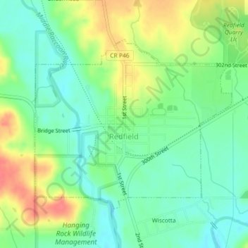
Name: Redfield topographic map, elevation, terrain.

Location: Redfield, Dallas County, Iowa, United States (41.58151 -94.20907 41.59999 -94.18018)

Average elevation: 298 m

Minimum elevation: 274 m

Maximum elevation: 335 m

Gear up for your next adventure:

🧢Sun Hat - Wide-brim hat for sun protection
🧥Waterproof Pants - Keep dry during rainy hiking conditions
🔋Emergency Crank Radio - Weather alerts and power without needing batteries
🥾Lightweight Hiking Shoes - Comfortable shoes for day hikes
🥾Waterproof Hiking Shoes - Durable shoes for wet and rugged trails

As an Amazon Associate, this site earns from qualifying purchases at no extra cost to you.