Geolocate

Calmar topographic map

Click on the map to display elevation.

About this map

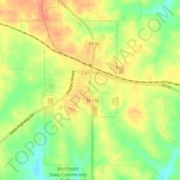
Name: Calmar topographic map, elevation, terrain.

Location: Calmar, Winneshiek County, Iowa, United States (43.16671 -91.87900 43.19353 -91.85927)

Average elevation: 376 m

Minimum elevation: 348 m

Maximum elevation: 396 m

Gear up for your next adventure:

🦶Anti-Blister Balm - Prevents friction and hotspots during long ascents
🍽️Titanium Camping Spork - Ultralight and indestructible eating utensil
🕯️Camping Lantern - Illuminates your entire campsite with high-efficiency LEDs
Backpacking Tent - Lightweight tent for long-distance hiking trips
🧥Packable Rain Jacket - Breathable waterproof layer for unpredictable weather

As an Amazon Associate, this site earns from qualifying purchases at no extra cost to you.