Geolocate

Charles City topographic map

Click on the map to display elevation.

About this map

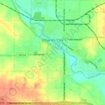
Name: Charles City topographic map, elevation, terrain.

Location: Charles City, Floyd County, Iowa, 50616, United States (43.03800 -92.70226 43.08347 -92.64336)

Average elevation: 315 m

Minimum elevation: 295 m

Maximum elevation: 340 m

Gear up for your next adventure:

🥾Durable Hiking Shoes - Long-lasting shoes for frequent hiking
🛶Canoe Life Vest - Safety vest for water sports
🧥Softshell Jacket - Windproof and breathable jacket for hiking
🔪Outdoor Multitool - Versatile tool for repairs and food prep in the wild
🚲Bike Repair Kit - Essential tools for on-trail mechanical issues

As an Amazon Associate, this site earns from qualifying purchases at no extra cost to you.