Geolocate

Adel topographic map

Click on the map to display elevation.

About this map

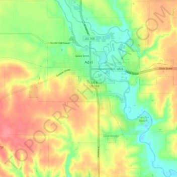
Name: Adel topographic map, elevation, terrain.

Location: Adel, Dallas County, Iowa, United States (41.58251 -94.05252 41.62953 -93.95048)

Average elevation: 292 m

Minimum elevation: 257 m

Maximum elevation: 328 m

Gear up for your next adventure:

Camping Essentials - All-in-one gear for a comfortable camping trip
🐕Hiking Dog Pack - Let your canine companion carry their own water and food
🕯️Camping Lantern - Illuminates your entire campsite with high-efficiency LEDs
Camping Tent - Weather-resistant tents suitable for 2 to 6 people
🔦LED Headtorch - Bright and durable light for night activities

As an Amazon Associate, this site earns from qualifying purchases at no extra cost to you.