
Skeena-Queen Charlotte topographic map
Interactive map
Click on the map to display elevation.
About this map
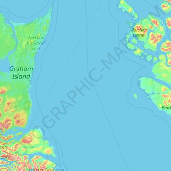
Name: Skeena-Queen Charlotte topographic map, elevation, terrain.
Location: Skeena-Queen Charlotte, Canada (52.92196 -131.87744 54.20196 -130.59744)
Average elevation: 37 m
Minimum elevation: -1 m
Maximum elevation: 1,032 m
Canada trails, hiking, mountain biking, running and outdoor activities
Other topographic maps
Click on a map to view its topography, its elevation and its terrain.
Ontario
Ontario's topography is a diverse tapestry shaped by its vast expanse and geological history. The Canadian Shield dominates the northern and central regions, characterized by ancient Precambrian rock formations, rugged terrain, and numerous lakes and rivers. In contrast, the Hudson Bay Lowlands in the far…
Average elevation: 245 m
Calgary
Calgary experiences a semi-monsoonal humid continental climate (Köppen climate classification Dwb) within eastern parts of the city and a subarctic climate (Köppen climate classification Dwc) within western parts of the city due to an increase in elevation. The city has warm, comfortable summers and…
Average elevation: 1,106 m
Ottawa
Ottawa, the capital city of Canada, is situated on the south bank of the Ottawa River at the confluence with the Rideau River. The city's topography is characterized by gently rolling terrain with elevations ranging from approximately 44 meters (144 feet) above sea level at the Ottawa River to its highest…
Average elevation: 105 m
Vancouver
Canada > British Columbia > Metro Vancouver Regional District
Vancouver, British Columbia, is situated on the Burrard Peninsula, bordered by Burrard Inlet to the north and the Fraser River to the south. The city's topography is a blend of flat and hilly terrains, with elevations ranging from sea level to approximately 152 meters (500 feet) above sea level. The North…
Average elevation: 34 m
Nova Scotia
Nova Scotia's topography is a diverse blend of rugged highlands, rolling hills, and fertile lowlands. The province's landscape is shaped by several upland regions, including the Southern Upland, North Mountain, and Cobequid Mountain, which are interspersed with extensive lowlands. The Southern Upland rises…
Average elevation: 41 m
British Columbia
British Columbia's topography is a testament to its diverse and dramatic landscapes. Dominated by the Cordillera region, the province features prominent mountain ranges such as the Coast Mountains in the west and the Rocky Mountains in the east. The Coast Mountains, composed of granite rocks from the…
Average elevation: 708 m
Quebec
Quebec's topography is characterized by three main physiographic regions: the Canadian Shield, the St. Lawrence Lowlands, and the Appalachian Mountains. The Canadian Shield, covering about 90% of the province, features rugged terrain with rocky plateaus, rolling hills, and numerous rivers and lakes formed by…
Average elevation: 195 m
Victoria
Canada > British Columbia > Capital Regional District
Victoria, British Columbia, is situated on the southern tip of Vancouver Island, Canada, and boasts a diverse and varied topography. The city is characterized by rolling hills, rugged coastal cliffs, and lush valleys, providing a striking contrast between mountainous terrain and flatland areas. To the north…
Average elevation: 17 m
Prince George
Canada > British Columbia > Regional District of Fraser-Fort George
Average elevation: 685 m
Regina
Unlike other planned cities in the Canadian West, on its treeless flat plain Regina has few topographical features other than the small spring run-off, Wascana Creek. Early planners took advantage of such opportunity by damming the creek to create a decorative lake to the south of the central business district…
Average elevation: 582 m
Burnaby
Canada > British Columbia > Metro Vancouver Regional District
Burnaby occupies 98.6 square kilometres (38.1 sq mi) and is located at the geographic centre of the Metro Vancouver Regional District. The regional district's government is located in Burnaby's Metrotown area. Situated between the city of Vancouver on the west and Port Moody, Coquitlam, and New Westminster on…
Average elevation: 59 m
Toronto
Despite its deep ravines, Toronto is not remarkably hilly, but its elevation does increase steadily away from the lake. Elevation differences range from 76.5 metres (251 ft) above sea level at the Lake Ontario shore to 209 m (686 ft) ASL near the York University grounds in the city's north end at the…
Average elevation: 139 m
British Columbia
British Columbia's topography is a testament to its diverse and dramatic landscapes. Dominated by the Cordillera region, the province features prominent mountain ranges such as the Coast Mountains in the west and the Rocky Mountains in the east. The Coast Mountains, composed of granite rocks from the…
Average elevation: 708 m
Richmond Hill
Canada > Ontario > York Region
The village of Richmond Hill was incorporated by a bylaw of the York County Council on June 18, 1872, coming into effect January 1, 1873. In September 1956, the Ontario Municipal Board approved its elevation to Town status, effective January 1, 1957.
Average elevation: 256 m
Central Ontario
Along the northern edge of Central Ontario, are some of the highest elevations in Southern Ontario. These highlands are known as the Opeongo Hills, and they stretch into portions of Eastern Ontario as well.
Average elevation: 255 m
Vancouver Island
The rain shadow effect of the island's mountains, as well as the mountains of Washington's Olympic Peninsula, creates wide variation in precipitation. The west coast is considerably wetter than the east coast. Average annual precipitation ranges from 6,650 mm (262 in) at Hucuktlis Lake on the west coast…
Average elevation: 411 m
Vancouver
Canada > British Columbia > Metro Vancouver Regional District
Vancouver, British Columbia, is situated on the Burrard Peninsula, bordered by Burrard Inlet to the north and the Fraser River to the south. The city's topography is a blend of flat and hilly terrains, with elevations ranging from sea level to approximately 152 meters (500 feet) above sea level. The North…
Average elevation: 34 m
Mission
Canada > British Columbia > Fraser Valley Regional District
The western part of the district, the Stave Valley, is largely rural and forested but its watercourse is home to what was the largest hydroelectric project in British Columbia until the Bridge River Power Project opened in 1961. It was built by the British Columbia Electric Railway (BCER) to provide power to…
Average elevation: 345 m
Penticton
Canada > British Columbia > Regional District of Okanagan-Similkameen
Penticton is located at the geographical coordinates of 49°29′28″N 119°35′19″W / 49.49111°N 119.58861°W / 49.49111; -119.58861 (Penticton) and covers an area of 42.10 km2 (16.25 sq mi), with a maximum north–south distance of 7 km (4.3 mi) wide between the Okanagan Lake to the north…
Average elevation: 702 m
Kelowna
Canada > British Columbia > Regional District of Central Okanagan
Kelowna is classified as a humid continental climate or an inland oceanic climate per the Köppen climate classification system due to its coldest month having an average temperature slightly above −3.0 °C (26.6 °F) and below 0 °C (32 °F), with dry, hot, sunny summers and cool, cloudy winters, and four…
Average elevation: 704 m
Edmonton
Edmonton is on the North Saskatchewan River, at an elevation of 671 m (2,201 ft). It is North America's northernmost city with a metropolitan population over one million. It is at the same latitude as Hamburg (Germany); Dublin (Ireland); Manchester (United Kingdom); and Magnitogorsk (Russia). It is south of…
Average elevation: 690 m
Newfoundland and Labrador
In 1496, John Cabot obtained a charter from English King Henry VII to "sail to all parts, countries and seas of the East, the West and of the North, under our banner and ensign and to set up our banner on any new-found-land" and on June 24, 1497, landed in Cape Bonavista. Historians disagree on whether Cabot…
Average elevation: 192 m
Area H (The Slocan Valley)
Canada > British Columbia > Regional District of Central Kootenay
Average elevation: 1,426 m
Township of Langley
Canada > British Columbia > Metro Vancouver Regional District
Average elevation: 47 m
Kitchener
Canada > Ontario > Region of Waterloo
Kitchener is located in Southwestern Ontario, in the Saint Lawrence Lowlands. This geological and climatic region has wet-climate soils and deciduous forests. Situated in the Grand River Valley, the area is generally above 300 m (1,000 ft) in elevation.
Average elevation: 336 m
Winnipeg
Winnipeg lies at the bottom of the Red River Valley, a flood plain with an extremely flat topography. It is on the eastern edge of the Canadian Prairies in Western Canada and is known as the "Gateway to the West". Winnipeg is bordered by tallgrass prairie to the west and south and the aspen parkland to the…
Average elevation: 236 m
Halifax
Canada > Nova Scotia > Halifax County
The coastline is heavily indented, accounting for its length of approximately 400 km (250 mi), with the northern boundary of the municipality usually being between 50–60 km (31–37 mi) inland. The coast is mostly rock with small isolated sand beaches in sheltered bays. The largest coastal features include…
Average elevation: 46 m
Mississauga
Canada > Ontario > Peel Region
The shoreline of former Glacial Lake Iroquois roughly follows the Dundas Street alignment, although it is not noticeable in some places but is more prominent in others, such as the site of the former brickyard (Shoreline Dr. near Mavis Rd.), the ancient shoreline promenteau affords a clear view of downtown…
Average elevation: 151 m
Gabriola Island
Canada > British Columbia > Regional District of Nanaimo > Area B (DeCourcy/Gabriola/Mudge)
Gabriola is about 14 kilometres (9 mi) long by 4.2 kilometres (2.6 mi) wide on average with a land area of 57.6 square kilometres (22.2 sq mi). The topography varies from flat sandy beaches at sea level to forested hills rising to 160 metres (525 ft) on Stoney Ridge in the centre of the island.
Average elevation: 26 m
Mont-Tremblant
Canada > Quebec > Les Laurentides
The city is dominated by Mont Tremblant with an altitude of 968m which is one of the highest peaks in southern Quebec.
Average elevation: 358 m
Coquitlam
Canada > British Columbia > Metro Vancouver Regional District
Like much of Metro Vancouver, Coquitlam has an oceanic climate (Köppen climate type Cfb), experiencing mild temperatures and high precipitation; warm, dry summers and cool, wet winters. However, compared to most other cities in the area, precipitation is especially heavy in Coquitlam due to its proximity to…
Average elevation: 190 m
Fredericton
Canada > New Brunswick > Kingsclear Parish > Fredericton
At an altitude of about 17 m (56 ft) above sea level, Fredericton is nestled in the Pennsylvanian Basin. It differs markedly from the geologically older parts of the province. There are prominently two distinct areas in the region that are divided around the area of Wilsey Road, in the east end of the city. In…
Average elevation: 72 m
Scarborough
Topographically, Scarborough is dominated by two watersheds, Highland Creek and the Rouge River. Highland Creek lies almost entirely within Scarborough and occupies approximately 70% of its total area. It occupies the western half of Scarborough, while the Rouge River flows through the eastern portion. Both of…
Average elevation: 138 m
Cape Breton Island
The island is characterized by a number of elevations of ancient crystalline and metamorphic rock rising up from the south to the north, and contrasted with eroded lowlands. The bedrock of blocks that developed in different places around the globe, at different times, and then were fused together via tectonics.
Average elevation: 66 m
Area D (Granby Valley)
Canada > British Columbia > Regional District of Kootenay Boundary
Average elevation: 1,284 m
Harris Lake
Canada > Ontario > Parry Sound District > Unorganized Centre Parry Sound
Average elevation: 209 m
Area H (Canim Lake/Forest Grove)
Canada > British Columbia > Cariboo Regional District
Average elevation: 1,228 m
Nose Hill Park
Names currently associated with topographical features in and near Nose Hill Park reflect the impact of the European newcomers and European trade goods on the Peigan. For example, Spy Hill, the westward extension of Nose Hill, derived its present name from the aboriginal practice of communicating with distant…
Average elevation: 1,174 m
Lake Ontario
Lake Ontario is the easternmost of the Great Lakes and the smallest in surface area (7,340 sq mi, 18,960 km2), although it exceeds Lake Erie in volume (393 cu mi, 1,639 km3). It is the 13th largest lake in the world. When its islands are included, the lake's shoreline is 712 miles (1,146 km) long. As the last…
Average elevation: 214 m
Quebec
Canada > Quebec > Urban agglomeration of Québec
Quebec City was built on the north bank of the Saint Lawrence River, where it narrows and meets the mouth of the Saint-Charles River. Old Quebec is located on top and at the foot of Cap-Diamant, which is on the eastern edge of a plateau called the promontory of Quebec (Quebec hill). Because of this topographic…
Average elevation: 117 m
Hamilton
Hamilton's climate is humid-continental, characterized by changeable weather patterns. In the Köppen classification, Hamilton it is on the Dfb/Dfa border found in southern Ontario because the average temperature in July is 22.0 °C (71.6 °F). However, its climate is moderate compared with most of Canada. The…
Average elevation: 187 m
Revelstoke
Canada > British Columbia > Columbia-Shuswap Regional District
A small ski resort featuring a single short lift has operated on Mount MacKenzie since the 1960s, and snowcat skiing was offered for higher altitudes. A strong movement pushed to expand the entire mountain into a single resort, and construction started in the early 2000s (decade).
Average elevation: 982 m
Newmarket
Canada > Ontario > York Region
Newmarket's geographical coordinates are 44.05°N, 79.46°W, and its elevation above sea level is 252 m. It has an area of 38.33 km². The town is bounded on the south by Aurora, on the west by King, on the north by East Gwillimbury and on the east by Whitchurch–Stouffville.
Average elevation: 270 m