
Cape Breton Island topographic map
Interactive map
Click on the map to display elevation.
About this map
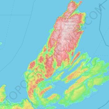
Name: Cape Breton Island topographic map, elevation, terrain.
Location: Cape Breton Island, Nova Scotia, Canada (45.54801 -61.55268 47.04205 -59.78811)
Average elevation: 66 m
Minimum elevation: -3 m
Maximum elevation: 531 m
The island is characterized by a number of elevations of ancient crystalline and metamorphic rock rising up from the south to the north, and contrasted with eroded lowlands. The bedrock of blocks that developed in different places around the globe, at different times, and then were fused together via tectonics.
Other topographic maps
Click on a map to view its topography, its elevation and its terrain.
Halifax
Canada > Nova Scotia > Halifax County
Halifax, Halifax Regional Municipality, Halifax County, Nova Scotia, Canada
Average elevation: 46 m
Dartmouth
Canada > Nova Scotia > Halifax County
Dartmouth, Halifax Regional Municipality, Halifax County, Nova Scotia, Canada
Average elevation: 45 m
Oak Island
Canada > Nova Scotia > Martins Point
Oak Island, Martins Point, Lunenburg County, Nova Scotia, Canada
Average elevation: 3 m
Munro Lake
Canada > Nova Scotia > Municipality of the County of Annapolis
Munro Lake, Municipality of the County of Annapolis, Annapolis County, Nova Scotia, B0S 1A0, Canada
Average elevation: 164 m
Lower Sackville
Canada > Nova Scotia > Halifax County
Lower Sackville, Halifax Regional Municipality, Halifax County, Nova Scotia, Canada
Average elevation: 63 m
Armstrong Lake
Canada > Nova Scotia > Municipality of the County of Kings
Armstrong Lake, Municipality of the County of Kings, Kings County, Nova Scotia, Canada
Average elevation: 208 m
Hilltown
Canada > Nova Scotia > Digby County
Hilltown, Clare Municipal District, Digby County, Nova Scotia, B0W 3T0, Canada
Average elevation: 91 m
Truro
Canada > Nova Scotia > Town of Truro
Truro, Town of Truro, Colchester County, Nova Scotia, Canada
Average elevation: 71 m
Cheverie
Canada > Nova Scotia > Hants County
Cheverie, Region of Windsor and West Hants Municipality, Hants County, Nova Scotia, B0N 1G0, Canada
Average elevation: 24 m
Oak Island
Canada > Nova Scotia > Lunenburg County > Western Shore
Oak Island, Western Shore, Chester District Municipality, Lunenburg County, Nova Scotia, B0J 3M0, Canada
Average elevation: 74 m
Bedford
Canada > Nova Scotia > Halifax County
Bedford, Halifax Regional Municipality, Halifax County, Nova Scotia, Canada
Average elevation: 46 m
Weymouth North
Canada > Nova Scotia > Digby County
Weymouth North, Digby Municipal District, Digby County, Nova Scotia, B0W 3T0, Canada
Average elevation: 30 m
Belliveaus Cove
Canada > Nova Scotia > Digby County
Belliveaus Cove, Clare Municipal District, Digby County, Nova Scotia, B0W 1J0, Canada
Average elevation: 32 m
Highland Village
Canada > Nova Scotia > Municipality of Colchester
Highland Village, Municipality of Colchester, Colchester County, Nova Scotia, Canada
Average elevation: 35 m
Oakland
Canada > Nova Scotia > Lunenburg County
Oakland, Municipality of the District of Lunenburg, Lunenburg County, Nova Scotia, B0J 2E0, Canada
Average elevation: 23 m
Atlantic
Canada > Nova Scotia > Atlantic
Atlantic, Municipality of the District of Shelburne, Shelburne County, Nova Scotia, Canada
Average elevation: 3 m
Point Pleasant Park
Canada > Nova Scotia > Halifax County > Halifax
Point Pleasant Park, Halifax, Halifax Regional Municipality, Halifax County, Nova Scotia, B3H 1B5, Canada
Average elevation: 12 m
Stanley Section
Canada > Nova Scotia > Lunenburg County
Stanley Section, Municipality of the District of Lunenburg, Lunenburg County, Nova Scotia, Canada
Average elevation: 98 m
Greenville
Canada > Nova Scotia > Yarmouth County
Greenville, Yarmouth Municipal District, Yarmouth County, Nova Scotia, Canada
Average elevation: 32 m
Barrington Passage
Canada > Nova Scotia > Shelburne County
Barrington Passage, Municipality of the District of Barrington, Shelburne County, Nova Scotia, B0W 1E0, Canada
Average elevation: 13 m
Municipality of the County of Kings
Municipality of the County of Kings, Kings County, Nova Scotia, Canada
Average elevation: 110 m
Melbourne
Canada > Nova Scotia > Yarmouth County
Melbourne, Yarmouth Municipal District, Yarmouth County, Nova Scotia, Canada
Average elevation: 12 m
Lake Annis
Canada > Nova Scotia > Yarmouth County
Lake Annis, Yarmouth Municipal District, Yarmouth County, Nova Scotia, B5A 5N4, Canada
Average elevation: 57 m
Springside
Canada > Nova Scotia > Municipality of Colchester
Springside, Eastville, Municipality of Colchester, Colchester County, Nova Scotia, Canada
Average elevation: 93 m
Frasertown
Canada > Nova Scotia > Municipality of the County of Annapolis > Princedale
Frasertown, Princedale, Municipality of the County of Annapolis, Annapolis County, Nova Scotia, B0S 1G0, Canada
Average elevation: 138 m
Upper Canard
Canada > Nova Scotia > Municipality of the County of Kings
Upper Canard, Municipality of the County of Kings, Kings County, Nova Scotia, Canada
Average elevation: 13 m
Central Woods Harbour
Canada > Nova Scotia > Shelburne County
Central Woods Harbour, Municipality of the District of Barrington, Shelburne County, Nova Scotia, Canada
Average elevation: 12 m
Gore
Canada > Nova Scotia > Hants County
Gore, East Hants District Municipality, Hants County, Nova Scotia, Canada
Average elevation: 103 m
West Lake Ainslie
Canada > Nova Scotia > Municipality of the County of Inverness
West Lake Ainslie, Municipality of the County of Inverness, Inverness County, Nova Scotia, Canada
Average elevation: 119 m
Black River
Canada > Nova Scotia > Municipality of Pictou County
Black River, Municipality of Pictou County, Pictou County, Nova Scotia, Canada
Average elevation: 63 m
Rocky Mountain
Canada > Nova Scotia > Municipality of Pictou County
Rocky Mountain, Municipality of Pictou County, Pictou County, Nova Scotia, B2H 5C8, Canada
Average elevation: 144 m
Englishtown
Canada > Nova Scotia > Municipality of Victoria County
Englishtown, Municipality of Victoria County, Victoria County, Nova Scotia, Canada
Average elevation: 116 m
Tusket
Canada > Nova Scotia > Yarmouth County
Tusket, Argyle Municipal District, Yarmouth County, Nova Scotia, B0W 3M0, Canada
Average elevation: 11 m
West Porters Lake
Canada > Nova Scotia > Halifax County
West Porters Lake, Halifax Regional Municipality, Halifax County, Nova Scotia, Canada
Average elevation: 14 m
Point Cross
Canada > Nova Scotia > Municipality of the County of Inverness
Point Cross, Municipality of the County of Inverness, Inverness County, Nova Scotia, Canada
Average elevation: 97 m
Spryfield
Canada > Nova Scotia > Halifax County > Halifax
Spryfield, Halifax, Halifax Regional Municipality, Halifax County, Nova Scotia, Canada
Average elevation: 67 m
Kolbec
Canada > Nova Scotia > Municipality of the County of Cumberland
Kolbec, Municipality of the County of Cumberland, Cumberland County, Nova Scotia, B0M 1P0, Canada
Average elevation: 44 m
Garlands Crossing
Canada > Nova Scotia > Hants County
Garlands Crossing, Region of Windsor and West Hants Municipality, Hants County, Nova Scotia, B0N 2T0, Canada
Average elevation: 29 m
Crowes Mills
Canada > Nova Scotia > Municipality of Colchester
Crowes Mills, Municipality of Colchester, Colchester County, Nova Scotia, Canada
Average elevation: 28 m
Deerfield
Canada > Nova Scotia > Yarmouth County
Deerfield, Yarmouth Municipal District, Yarmouth County, Nova Scotia, B5A 5N7, Canada
Average elevation: 40 m
Upper Dyke
Canada > Nova Scotia > Municipality of the County of Kings
Upper Dyke, Municipality of the County of Kings, Kings County, Nova Scotia, Canada
Average elevation: 18 m
Barneys River Station
Canada > Nova Scotia > Municipality of Pictou County
Barneys River Station, Municipality of Pictou County, Pictou County, Nova Scotia, Canada
Average elevation: 145 m
College Grant
Canada > Nova Scotia > Municipality of Pictou County
College Grant, Municipality of Pictou County, Pictou County, Nova Scotia, Canada
Average elevation: 84 m
Margaree Harbour
Canada > Nova Scotia > Municipality of the County of Inverness
Margaree Harbour, Municipality of the County of Inverness, Inverness County, Nova Scotia, Canada
Average elevation: 108 m
Municipality of Colchester
Municipality of Colchester, Colchester County, Nova Scotia, Canada
Average elevation: 91 m
Elmsdale
Canada > Nova Scotia > Hants County
Elmsdale, East Hants District Municipality, Hants County, Nova Scotia, Canada
Average elevation: 24 m
Maitland
Canada > Nova Scotia > Hants County
Maitland, East Hants District Municipality, Hants County, Nova Scotia, Canada
Average elevation: 39 m
Hadleyville
Canada > Nova Scotia > Guysborough District Municipality
Hadleyville, Guysborough District Municipality, Guysborough County, Nova Scotia, Canada
Average elevation: 34 m
East Ferry
Canada > Nova Scotia > Digby County
East Ferry, Digby Municipal District, Digby County, Nova Scotia, B0V 1E0, Canada
Average elevation: 22 m