
Penticton topographic map
Click on the map to display elevation.
Penticton
Penticton is located at the geographical coordinates of 49°29′28″N 119°35′19″W / 49.49111°N 119.58861°W / 49.49111; -119.58861 (Penticton) and covers an area of 42.10 km2 (16.25 sq mi), with a maximum north–south distance of 7 km (4.3 mi) wide between the Okanagan Lake to the north and Skaha Lake to the south; these lakes are part of the drainage system of the Okanagan River, a tributary of the Columbia River. Its borders are formed by Skaha Lake Road to the south and west, which changes to Highway 97 after city limits, Naramata Road to the east, and to the west, Highway 97. Penticton has an elevation of 385 m (1,263 ft), and is situated five hours from Seattle, Washington, or Vancouver, British Columbia, and eight hours from Calgary, Alberta, by highway.
About this map
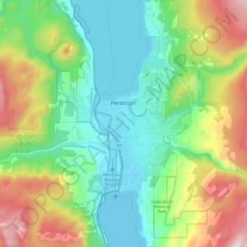
Name: Penticton topographic map, elevation, terrain.
Average elevation: 702 m
Minimum elevation: 334 m
Maximum elevation: 1,530 m
Other topographic maps
Click on a map to view its topography, its elevation and its terrain.
Hedley
Canada > British Columbia > Regional District of Okanagan-Similkameen > Area G (Upper Similkameen/Hedley)
Average elevation: 822 m
Naramata
Canada > British Columbia > Regional District of Okanagan-Similkameen > Area E (Naramata/Greyback)
Average elevation: 414 m
Manning Park
Canada > British Columbia > Regional District of Okanagan-Similkameen > Area H (Manning Park/Tulameen/Siwash)
Average elevation: 1,420 m
Agur Lake
Canada > British Columbia > Regional District of Okanagan-Similkameen > Area F (Trout Creek Valley)
Average elevation: 1,178 m
Faulder
Canada > British Columbia > Regional District of Okanagan-Similkameen > Area F (Trout Creek Valley)
Average elevation: 850 m
Bankeir
Canada > British Columbia > Regional District of Okanagan-Similkameen > Area H (Manning Park/Tulameen/Siwash)
Average elevation: 1,226 m
Garnet Valley Dam
Canada > British Columbia > Regional District of Okanagan-Similkameen > Summerland
Average elevation: 799 m
Chapman Lake
Canada > British Columbia > Regional District of Okanagan-Similkameen > Area H (Manning Park/Tulameen/Siwash)
Average elevation: 1,669 m
Glacier Lake
Canada > British Columbia > Regional District of Okanagan-Similkameen > Area G (Upper Similkameen/Hedley)
Average elevation: 2,291 m
Cascade Mountains
Canada > British Columbia > Regional District of Okanagan-Similkameen > Area B (Cawston/Lower Similkameen)
Average elevation: 1,207 m
Tulameen
Canada > British Columbia > Regional District of Okanagan-Similkameen > Area H (Manning Park/Tulameen/Siwash)
Average elevation: 923 m
Allison Lake
Canada > British Columbia > Regional District of Okanagan-Similkameen > Area H (Manning Park/Tulameen/Siwash)
Average elevation: 1,141 m
Okanagan Falls
Canada > British Columbia > Regional District of Okanagan-Similkameen > Area D (Skaha East/Okanagan Falls)
Average elevation: 478 m
Cawston
Canada > British Columbia > Regional District of Okanagan-Similkameen > Area B (Cawston/Lower Similkameen)
Average elevation: 410 m
Penticton
Canada > British Columbia > Regional District of Okanagan-Similkameen > Penticton
Penticton is located at the geographical coordinates of 49°29′28″N 119°35′19″W / 49.49111°N 119.58861°W / 49.49111; -119.58861 (Penticton) and covers an area of 42.10 km2 (16.25 sq mi), with a maximum north–south distance of 7 km (4.3 mi) wide between the Okanagan Lake to the north…
Average elevation: 1,044 m
Okanagan Highland
Canada > British Columbia > Regional District of Okanagan-Similkameen > Area E (Naramata/Greyback)
Average elevation: 816 m
Greyback Lake
Canada > British Columbia > Regional District of Okanagan-Similkameen > Area E (Naramata/Greyback)
Average elevation: 1,627 m
Marron Valley
Canada > British Columbia > Regional District of Okanagan-Similkameen > Area I (Skaha West/Kaleden/Apex)
Average elevation: 772 m
Rampart Lake
Canada > British Columbia > Regional District of Okanagan-Similkameen > Area H (Manning Park/Tulameen/Siwash)
Average elevation: 1,333 m
Chute Lake
Canada > British Columbia > Regional District of Okanagan-Similkameen > Area E (Naramata/Greyback)
Average elevation: 1,273 m
Allenby
Canada > British Columbia > Regional District of Okanagan-Similkameen > Area H (Manning Park/Tulameen/Siwash)
Average elevation: 850 m
Olivine Mountain
Canada > British Columbia > Regional District of Okanagan-Similkameen > Area H (Manning Park/Tulameen/Siwash)
Average elevation: 1,537 m
Blakeburn
Canada > British Columbia > Regional District of Okanagan-Similkameen > Area H (Manning Park/Tulameen/Siwash)
Average elevation: 1,188 m
Jellicoe
Canada > British Columbia > Regional District of Okanagan-Similkameen > Area H (Manning Park/Tulameen/Siwash)
Average elevation: 1,206 m
Chain Lake
Canada > British Columbia > Regional District of Okanagan-Similkameen > Area H (Manning Park/Tulameen/Siwash)
Average elevation: 1,165 m
Frosty Mountain
Canada > British Columbia > Regional District of Okanagan-Similkameen > Area H (Manning Park/Tulameen/Siwash)
Average elevation: 2,010 m
Isintok Mountain
Canada > British Columbia > Regional District of Okanagan-Similkameen > Area F (Trout Creek Valley)
Average elevation: 1,739 m
Coalmont
Canada > British Columbia > Regional District of Okanagan-Similkameen > Area H (Manning Park/Tulameen/Siwash)
Average elevation: 966 m
Manning Park
Canada > British Columbia > Regional District of Okanagan-Similkameen > Area H (Manning Park/Tulameen/Siwash)
Average elevation: 1,420 m
Cascade Mountains
Canada > British Columbia > Regional District of Okanagan-Similkameen > Area B (Cawston/Lower Similkameen)
Average elevation: 1,207 m
Hedley
Canada > British Columbia > Regional District of Okanagan-Similkameen > Area G (Upper Similkameen/Hedley)
Average elevation: 822 m
Okanagan Falls
Canada > British Columbia > Regional District of Okanagan-Similkameen > Area D (Skaha East/Okanagan Falls)
Average elevation: 478 m
Cascade Mountains
Canada > British Columbia > Regional District of Okanagan-Similkameen > Area G (Upper Similkameen/Hedley)
Average elevation: 1,979 m
Tulameen
Canada > British Columbia > Regional District of Okanagan-Similkameen > Area H (Manning Park/Tulameen/Siwash)
Average elevation: 923 m