
Otter Tail County topographic map
Interactive map
Click on the map to display elevation.
About this map
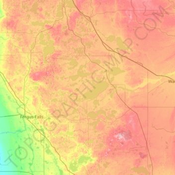
Name: Otter Tail County topographic map, elevation, terrain.
Location: Otter Tail County, Minnesota, United States (46.10676 -96.28123 46.71779 -95.14567)
Average elevation: 413 m
Minimum elevation: 306 m
Maximum elevation: 542 m
Other topographic maps
Click on a map to view its topography, its elevation and its terrain.
Eagle Mountain
United States > Minnesota > Cook County
Eagle Mountain is only about 15 miles (24 km) from Minnesota's lowest elevation, Lake Superior, at 600 feet (183 m). It is part of the Canadian Shield. There is also another much shorter peak also named Eagle Mountain in northern Minnesota. The shorter peak is part of the Lutsen Mountains ski resort.
Average elevation: 596 m
Barnes Lake
United States > Minnesota > Carver County > Norwood Young America
Average elevation: 300 m
North Shore Mining/Lake Superior Overlook
United States > Minnesota > Lake County > Silver Bay
Average elevation: 252 m
Minneapolis
United States > Minnesota > Hennepin County > Minneapolis
A 1959 report by the U.S. Soil Conservation Service listed Minneapolis's elevation as 830 feet (250 m). The city's lowest elevation of 687 feet (209 m) above sea level is near where Minnehaha Creek meets the Mississippi River. Sources disagree on the exact location and elevation of the city's highest point,…
Average elevation: 271 m
Silver Lake
United States > Minnesota > McLeod County > Silver Lake > Silver Lake
Average elevation: 320 m
Maple Lake
United States > Minnesota > Wright County > Maple Lake > Maple Lake
Average elevation: 314 m
Fergus Falls
United States > Minnesota > Otter Tail County > Fergus Falls > Fergus Falls
Average elevation: 375 m