Geolocate

Maplewood topographic map

Click on the map to display elevation.

About this map

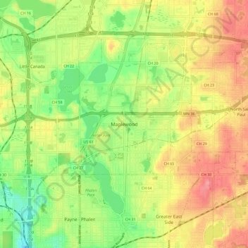
Name: Maplewood topographic map, elevation, terrain.

Location: Maplewood, Ramsey County, Minnesota, 55109, United States (44.96822 -93.08570 45.04822 -93.00570)

Average elevation: 282 m

Minimum elevation: 236 m

Maximum elevation: 328 m

Gear up for your next adventure:

🧥Thermal Layer - Insulating layer for cold outdoor conditions
👟Trail Running Shoes - Agile footwear for fast-paced topographic exploration
🥾Waterproof Trail Shoes - Shoes designed to handle wet terrain
🧳Compression Sacks - Maximize space in your backpack by shrinking gear
🧭Orienteering Kit - Tools for map reading and navigation in the wild

As an Amazon Associate, this site earns from qualifying purchases at no extra cost to you.