Geolocate

Jack Lake topographic map

Click on the map to display elevation.

About this map

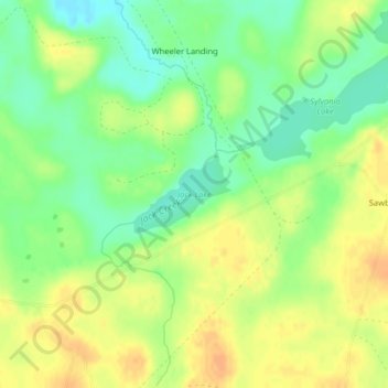
Name: Jack Lake topographic map, elevation, terrain.

Location: Jack Lake, Lake County, Minnesota, United States (47.71304 -91.29541 47.71854 -91.28528)

Average elevation: 509 m

Minimum elevation: 491 m

Maximum elevation: 524 m

Other topographic maps

Click on a map to view its topography, its elevation and its terrain.

Alice Lake

United States > Minnesota > Lake County

Average elevation: 474 m

Isabella

United States > Minnesota > Lake County > Isabella

Average elevation: 594 m

Link Lake

United States > Minnesota > Lake County

Average elevation: 452 m

Makwa Lake

United States > Minnesota > Lake County

Average elevation: 509 m

Cook Lake

United States > Minnesota > Lake County

Average elevation: 534 m

Raven Lake

United States > Minnesota > Lake County

Average elevation: 507 m

Gear up for your next adventure:

🩹Compact First Aid Kit - Pre-packed essentials for common trail injuries
🦶Hiking Shoe Insoles - Added support for high arches and long days on feet
🧭GPS Handheld Device - Reliable GPS navigation for outdoor adventures
🧢Hiking Sun Hat - Wide-brimmed protection for exposed mountain ridges
🥾Trail Hiking Boots - Supportive boots for rough trails

As an Amazon Associate, this site earns from qualifying purchases at no extra cost to you.